What are data and information, why they matter (v. ITA 2021)
•
0 gefällt mir•283 views

Quick introduction to the Data & Content Storytelling course @IED Milano. History of data gathering and data visualization.

Empfohlen
Empfohlen
Weitere ähnliche Inhalte
Ähnlich wie What are data and information, why they matter (v. ITA 2021)
Ähnlich wie What are data and information, why they matter (v. ITA 2021) (20)
Mehr von Frieda Brioschi
Mehr von Frieda Brioschi (20)
Kürzlich hochgeladen
Kürzlich hochgeladen (20)
What are data and information, why they matter (v. ITA 2021)
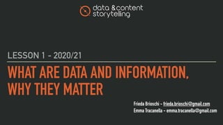
- 1. Frieda Brioschi - frieda.brioschi@gmail.com Emma Tracanella - emma.tracanella@gmail.com WHAT ARE DATA AND INFORMATION, WHY THEY MATTER LESSON 1 - 2020/21
- 2. HERE WE ARE 2 EMMA TRACANELLA FRIEDA BRIOSCHI
- 3. A QUICK INTRO LET’S START
- 4. LESSON 1 THE MATERIAL ‣ progettareidee.wordpress.com ‣ slideshare ‣ Links ‣ Your minds! 4
- 6. AND YOU? SHARE YOUR DATA! ▸ https://forms.gle/qmgA7jFQSwVNrdUF6 6
- 7. TOUR QUICK
- 10. LESSON 1 L3 10
- 11. LESSON 1 L4 11
- 12. LESSON 1 L5 12
- 13. LESSON 1 L6 13
- 14. LESSON 1 L7 14
- 15. LESSON 1 L8 15
- 16. LESSON 1 L9 16
- 17. LESSON 1 L10 17
- 18. LESSON 1 L11 18
- 19. LESSON 1 L12 19
- 20. APPROACH OUR
- 21. LESSON 1 3 AREAS, 1 VISION ▸ Data gathering ▸ Data storage, organization and analysis ▸ Data visualization and presentation 21
- 22. LESSON 1 WHAT ARE DATA Data are individual units of information. A datum describes a single quality or quantity of some object or phenomenon. Data are measured, collected and reported, and analyzed, whereupon they can be visualized using graphs, images or other analysis tools. 22
- 23. LESSON 1 WHAT IS INFORMATION Information is associated with data: is data in context and with meaning attached. Data are collected and analyzed and only becomes information once they have been analyzed in some fashion. 23
- 24. KNOWLEDGE IS POWER sir Francis Bacon LESSON 1 24
- 26. LESSON 1 WHEN DATA BEGAN Data gathering has been happening since the days of handwritten graphs. 26
- 27. LESSON 1 TALLY STICKS ▸ A tally stick was an ancient memory aid device used to record and document numbers, quantities, or even messages. Tally sticks first appear as animal bones carved with notches during the Upper Palaeolithic ▸ Tallies have been used for numerous purposes such as messaging and scheduling, and especially in financial and legal transactions, to the point of being currency ▸ https://en.wikipedia.org/wiki/Tally_stick 27
- 28. LESSON 1 ABACUS ▸ It’s a calculating tool that was in use in the ancient Near East, Europe, China, and Russia, centuries before the adoption of the written Hindu–Arabic numeral system ▸ https://en.wikipedia.org/wiki/Abacus 28
- 29. LESSON 1 LIBRARY OF ALEXANDRIA ▸ The Great Library of Alexandria in Alexandria, Egypt, was one of the largest and most significant libraries of the ancient world. ▸ It is unknown precisely how many papyrus scrolls were housed at any given time, but estimates range from 40,000 to 400,000. ▸ Despite the modern belief that the Library was burned once and then destroyed, it actually declined gradually over the course of several centuries ▸ https://en.wikipedia.org/wiki/Library_of_Alexandria 29
- 30. LESSON 1 JOHN GRAUNT (1620–1674) ▸ Along with William Petty, developed early human statistical and census methods that later provided a framework for modern demography ▸ In 1663, in his book Natural and Political Observations Made upon the Bills of Mortality he used analysis of the weekly statistics of deaths in early modern London to create a system to warn of the onset and spread of bubonic plague in the city. Though the system was never truly created, Graunt's work in studying the rolls resulted in the first statistically based estimation of the population of London. 30
- 31. LESSON 1 HERMAN HOLLERITH (1860–1929) ▸ He was an American inventor who developed an electromechanical punched card tabulator to assist in summarizing information ▸ There were so many more inquiries of all kinds in the census of 1880 that almost a full decade was needed to publish all the results ▸ He developed a mechanism using electrical connections to increment a counter, recording information. A key idea was that a datum could be recorded by the presence or absence of a hole at a specific location on a card 31
- 32. LESSON 1 FRITZ PFLEUMER (1860–1929) ▸ He was a German-Austrian engineer who invented magnetic tape for recording data ▸ The principles he develops are still in use today, with the vast majority of digital data being stored magnetically on computer hard disks. 32
- 33. LESSON 1 THE HISTORY OF DATA VISUALIZATION ▸ The term “Data Visualization” may have firm roots in the 20th Century, but the concept of data storytelling is as old as time. ▸ The earliest data table in known existence was created during the 2nd century in Egypt, cataloging astrological information to aide navigation practices of the day. ▸ A table is a textual representation of data: a way to arrange information into columns and rows for easier visualization. 33
- 34. LESSON 1 THE HISTORY OF DATA VISUALIZATION ▸ It’s a long story. ▸ A journey of all of history’s best graphs, charts, maps, and diagrams ▸ https://infowetrust.com/scroll/ 34
- 35. LESSON 1 RENE DESCARTES (1596 - 1650) ▸ Rene Descartes invents the Cartesian coordinate system, the X and Y axes graph. This french philosopher and mathematician gave us the X and Y axes, and perhaps the first truly visual representation of quantitative data. 35
- 36. LESSON 1 WILLIAM PLAYFAIR (1759–1823) ▸ Playfair was a Scottish engineer and political economist who published The Commercial and Political Atlas in 1786. ▸ He is considered the father of statistical graphics, having invented the line and bar chart we use so often today. He is also credited with having created the area and pie chart. ▸ Here he compares exports from England with imports into England from Denmark and Norway from 1700 to 1780. ▸ https://en.wikipedia.org/wiki/William_Playfair 36
- 37. LESSON 1 FLORENCE NIGHTINGALE (1820–1910) ▸ Florence Nightingale is famous for her work as a nurse during the Crimean War, but she was also a data journalist. ▸ She realized soldiers were dying from poor sanitation and malnutrition, so she kept meticulous records of the death tolls in the hospitals and visualized the data. ▸ Here we have an example of her coxcomb or rose diagrams that helped her fight for better hospital conditions and ultimately save lives. ▸ https://en.wikipedia.org/wiki/Florence_Nightingale 37
- 38. LESSON 1 TABLE, BAR CHARTS AND COXCOMBS ▸ Coxcombs, just like bar charts or pie charts, are graphical systems of representing data. They are sometimes called polar area charts or roses. (Despite many claims to the contrary, Nightingale did not originally refer to the graphs as coxcombs). ▸ https://understandinguncertainty.org/coxcombs 38 Category Value A 1 B 3 C 2
- 39. LESSON 1 JOHN SNOW (1813–1858) ▸ In 1854, a cholera epidemic spread quickly through Soho in London. The Broad Street area had seen over 600 dead, and the remaining residents and business owners had largely fled the terrible disease. ▸ Physician John Snow plotted the locations of cholera deaths on a map. The surviving maps of his work show a method of tallying the death counts, drawn as lines parallel to the street, at the appropriate addresses. Snow’s research revealed a pattern. He saw a clear concentration around the water pump on Broad Street, helping to find the cause of the infection. ▸ https://en.wikipedia.org/wiki/John_Snow 39
- 40. LESSON 1 CHARLES JOSEPH MINARD (1781–1870) ▸ Charles Joseph Minard was a French civil engineer famous for his representation of numerical data on maps. His most famous work is the map of Napoleon’s Russian campaign of 1812 displaying the dramatic loss of his army over the advance on Moscow and the following retreat. ▸ You can see how many soldiers are still marching and how many died. Drawn in 1869, it is described by many as the best statistical graphic ever drawn. It represents the earliest beginnings of data journalism. ▸ https://en.wikipedia.org/wiki/Charles_Joseph_Minard 40
- 41. LESSON 1 EDMOND HALLEY (1656–1742) ▸ Edmond Halley was an English astronomer, geophysicist, mathematician, meteorologist, and physicist who is best known for computing the orbit of Halley’s Comet. ▸ Halley developed the use of contour lines on maps to connect and describe areas that display differences in atmospheric conditions from place to place. These lines are now commonly used to describe meteorological variation common to us from weather reports. 41
- 42. LESSON 1 CHARLES DE FOURCROY (1766–1824) ▸ Charles de Fourcroy was a French mathematician and scholar. He produced a visual analysis of the work of French civil engineers and a comparison of the demographics of European cities. ▸ In 1782 he published Tableau Poléometrique, a treatise on engineering and civil construction. His use of geometric shapes predates the modern treemap, which is widely used today to display hierarchical data. 42
- 43. LESSON 1 LUIGI PEROZZO (1856–1916) ▸ Luigi Perozzo was an Italian mathematician and statistician who stood out for being the first to introduce 3D graphical representations, showing the relationships between three variables on the same graph. ▸ Perozzo published one of the first 3D representations of data showing the age group of the Swedish population between the 18th and 19th centuries. 43
- 51. LESSON 1 LA PRIMA DASHBOARD SUL COVID-19 ▸ è stata realizzata da Johns Hopkins CSSE ▸ https://www.arcgis.com/apps/opsdashboard/index.html#/bda7594740fd40299423467b48e9ecf6 51
- 52. LESSON 1 UN MODO DIVERSO DI PRESENTARE I DATI ▸ Lab24 del Sole24Ore ▸ https://lab24.ilsole24ore.com/coronavirus/ ▸ 52
- 53. LESSON 1 EFFETTI DELLA COMUNICAZIONE ▸ https://vincos.it/2020/03/04/corona-virus-gli-effetti-di-una-comunicazione-incoerente/ 53
- 54. LESSON 1 PER APPROFONDIRE ▸ https://multimedia.scmp.com/infographics/news/china/article/3047038/wuhan-virus/index.html?src=article-launcher 54