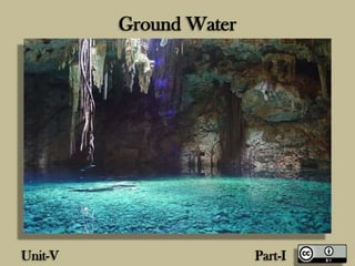
Ground Water (Unit-V)
•
300 gefällt mir•53,426 views

Ground Water (Unit-V) Engg Geology

Empfohlen
Weitere ähnliche Inhalte
Was ist angesagt?
Was ist angesagt? (20)
Andere mochten auch
Andere mochten auch (18)
Ähnlich wie Ground Water (Unit-V)
Ähnlich wie Ground Water (Unit-V) (20)
Mehr von GAURAV. H .TANDON
Mehr von GAURAV. H .TANDON (20)
Kürzlich hochgeladen
Kürzlich hochgeladen (20)
Ground Water (Unit-V)
- 2. Ground Water Ground water • Sources and zones, water table, unconfined and perched, springs, Factors controlling water bearing capacity of rocks, pervious and impervious rocks, cone of depression and its use in civil engineering, Methods of artificial recharge of ground water, geology of percolation tank. Geophysical Investigation Necessity, Methods of surface and sub surface investigations, Importance of Electrical Resistivity Method, Seismic Refraction Method, Preliminary geological investigations, Use of aerial photographs and satellite imageries in civil engineering projects
- 3. Ground Water • The ground water is considered a very important natural resource, in arid , semi arid and dry regions, this may be the only source of water supply. Even in humid areas, groundwater is considered a better resource for many economic and hygienic reasons.
- 4. Ground Water
- 5. Ground Water Ground Water • Has a suitable composition in most cases and is free from turbidity, objectionable colors, and pathogenic organisms and require not much treatment. • Is relatively much safer from hazards of chemical, radiogenic and biological pollution to which surface water bodies are exposed • Supplies are not quickly affected by drought and other climatic changes and hence are more dependable. • Being available locally in many cases may be tapped and distributed at much lesser cost using very little network of pipes
- 6. Ground Water
- 7. Ground Water Sources of groundwater Meteoric Water • It is the water derived from precipitation (rain and snow) although bulk of the rain water or melt water from snow and ice reaches the sea through the surface flows or runoffs a considerable part of precipitation gradually infiltrates into ground water. This infiltrated water continuous its downward journey till it reaches the zone of saturation to become the ground water in the aquifer. • Almost entire water obtained from ground water supplies belongs to this category.
- 9. Ground Water Connote Water • This is the water present in the rocks right from the time of their deposition in an aqueous environment. During the process of formation of sedimentary rock in a lake or sea or river, depositions is followed by compaction, which leads to the squeezing out of most of the water present between the sediments. Sometimes however, incomplete compaction may cause retention of some water by these rocks which is known as connote water. And it may be found in rocks like limestone, sandstone and gravels. It is saline in nature and is of no importance as a source for exploitable groundwater.
- 10. Ground Water
- 11. Ground Water Juvenile Water • It is also called magmatic water and is of only theoretical importance as far as water supply scheme is concerned. It is the water found in the cracks or crevices or porous of rocks due to condensation of steam emanating from hot molten masses or magmas existing below the surface of the earth. Some hot springs and geysers are clearly derived from juvenile water.
- 12. Ground Water Distribution of Ground Water • The water that goes below the surface of the land may be found to exist in two main zones or environments classified as Vadosa Water and phreatic water or groundwater • In the vadosa water zone itself, three different types of environment are distinguished; soil water, intermediate vadose water and capillary water.
- 13. Ground Water • The soil water forms a thin layer confined to the near surface depth of the land. It may occur at depth between 1.0 to 9 m and is held up by the root zone of vegetable cover of the globe It is lost to the atmosphere by transpiration and evaporation. • The intermediate vadosa zone occurs immediately below the zone of soil water. It is in fact a zone of non saturation; water in this zone is moving downward under the influence of gravity. It is generally of smaller thickness and may be even absent in many cases. The above zones are sometimes collectively referred as zone of aeration. • The zone of capillary water, also called as capillary fringe. Is present only in soil and rocks of fine particles size underlying the vadosa zone. In the fine particle size zone, groundwater is drawn upward by capillary action, sometimes to height of 2-3 m above saturated zone lying underneath. Growth of vegetation in some desert is very often dependent on presence of capillary fringe.
- 14. Ground Water
- 15. Ground Water
- 16. Ground Water
- 17. Distribution of Ground Water
- 18. Ground Water The Phreatic Water Zone • Also known as zone of saturation lies below the capillary fringe and is the water held in this zone that is called groundwater in the real sense. The upper surface of water in the zone marks the water table in the area. In this zone the layers or bodies of rocks which are porous and permeable, have all their open spaces such as pores, cavities, cracks etc. completely filled with water. All these openings are interconnected, so that a well dug into this openings are completely filled with water, there is no or very little downward movement of groundwater. In all ground water exploration programmes, the main objective is to locate this zone and determine its extent, geometry and character.
- 19. Ground Water
- 20. Ground Water
- 21. Ground Water Forms of Subsurface Water • Water in the soil mantle is called subsurface water and is considered in two zones • Saturated Zone • Aeration Zone.
- 22. Water table generally below surface, so water can seep in Water can soak into subsurface and become groundwater Where water table intersects surface, water can flow out
- 23. Ground Water
- 24. Ground Water Saturated Zone • This Zone is also known as groundwater zone in which all the pores of the soil are filled with water. The water table forms the upper limit and marks a free surface, i.e. a surface having atmospheric pressure.
- 25. Ground Water Zone of Aeration • In this zone the soil pores are only partially saturated with water. The spaces between the land surface and the water table marks the extent of this zone. The zone of aeration has three subzones.
- 26. Ground Water
- 27. Ground Water Soil water zone • This lies close to the ground surface in the major band of the vegetation from which the water is lost to the atmosphere by evapotranspiration. Capillary Fringe • In this the water is held by the capillary action. This zone extends from water table upwards to the limit of the capillary rise. Intermediate Zone • This lies between the soil water zone and the capillary fringe. The soil texture and moisture content and vary from region to region. The soil moisture in the zone of aeration is of importance in agricultural practices and irrigation engineering.
- 28. Ground Water
- 29. Ground Water Saturated Formations • All earth materials from soils to rocks have pore spaces. Although these pores are completely saturated with water table below, from the groundwater utilization aspect only such material through which water moves easily and hence can be extracted with ease are significant. On this basis the saturated formation are classified into four categories. • Aquifer • Aqitard • Aquiclude • Aquifuge
- 30. Ground Water Aquifer • An aquifer is a saturated formation of earth material which not only stores water but yields it in sufficient quantity. Thus an aquifer transmits water relatively easily due to high permeability. Unconsolidation deposits off sand and gravel form good aquifer.
- 31. Ground Water
- 32. Ground Water Aquitard • It is a formation through which only seepage is possible and thus the yield is insignificant compared to an aquifer. It is partly permeable. A sandy clay unit is an example of aquitard. Through an aquitard appreciable quantities of water may leak to an aquifer below it.
- 33. Ground Water
- 34. Ground Water Aqiclude It is a geological formation which is essentially impermeable to the flow of water. It may be considered as close to water movement even though it may contain large amount of water due to its high porosity. Clay is an example of an acquiclude.
- 35. Ground Water
- 36. Ground Water Aquifuge • It is a geological formation which neither porous nor permeable. There are no interconnected openings and hence it cannot transmit water. Massive compact rock without any fracture is an acquifuge.
- 37. Ground Water Aquifer • Formation of ground which contain water and may transmit water in usable quantity are known as aquifer. Thus these are the geological formations in which groundwater occurs. (i.e. Sands, gravels).
- 38. Confined aquifer overlain by less permeable materials Unconfined aquifer open to Earth’s surface and to infiltration Perched aquifer underlain by low-permeability unit Artesian aquifer: water rises in pipe (maybe to surface)
- 39. Ground Water Aquifer are mainly of two types Unconfined Aquifer • An unconfined aquifer is the one in which water table forms the upper surface of the zone of saturation. An aquifer where the water table is the upper surface limit and extends below till the impermeable rock strata is called the unconfined aquifer. Confined Aquifer • When an aquifer is sandwiched between two impermeable layers, it is known as a confined aquifer. It is also known as a pressure aquifer, or an artesian aquifer. Confined aquifers are completely filled with water and they do not have a free water table and the aquifer will be under pressure.
- 40. Ground Water
- 41. Ground Water Leaky Aquifer • An aquifer bound by one or two aquitards is known as a leaky aquifer. It is also known as semi- confined aquifer. Perched Aquifer Perched Aquifer is a special type of an unconfined aquifer. An impermeable saucer-shaped stratum of a small aerial extent occurring in the zone of aeration may retain and hold some amount of water is called perched aquifer.
- 42. Ground Water
- 43. Ground Water
- 44. Ground Water Water Table A water table is the free water surface in an unconfined aquifer indicating the level of the water table at that point. The water table is constantly in motion adjusting its surface to achieve a balance between the recharge and outflow from the surface storage.
- 45. Ground Water
- 46. Water Table • Fluctuations in the water level in a dug well during various seasons of the year, lowering of the groundwater table in a region due to heavy pumping of the wells and the rise in the water table of an irrigated area with poor drainage, are some common examples of the fluctuation of the water table. In a general sense, the water table follows the topographic features of the surface. If the water table intersects the land surface the ground water comes out to the surface in the form of springs or seepage.
- 47. Ground Water
- 48. Aquifer Character of Commonly Occurring Rocks Igneous Rocks • Among different igneous rocks we know that there are three subdivisions: Plutonic, hyperbassal and volcanic, granites, dolerite and basalts are the most abundant among these subdivisions, respectively. Of these. • Granite and dolerites have not only an interlocking texture but also being intrusive, they are massive, dense and compact. As a result they have negligible porosity and permeability. • So these rocks are typical examples of aquifuges. They can bear ground water only when they are either intensely fractured or have undergone considerable weathering.
- 49. Aquifer Character of Commonly Occurring Rocks • However, as both weathering and fracturing decreases with depth and disappears, no ground water can be expected in such rock at great depth. Volcanic rocks are often vesicular, In these vesicles are of considerable size and number and if these are interconnected they can serve as aquifer. • The contraction joints and other fractures, if present, also contribute to the porosity and permeability character of igneous rocks.
- 50. Igneous Rocks
- 51. Aquifer Character of Commonly Occurring Rocks Sedimentary Rocks • Among Sedimentary Rocks, the most common ones are shales, sandstones ad limestones. Of these sandstones and shales are formed out of the deposition of mechanically transported sediment. • A generalization may be made that coarse, rounded, sorted, less compacted and poorly cemented rocks are more porous. In this case of dense and fine grained limestone, they have no primary porosity, but solution cavities and channels are common in them which sometimes make these rocks highly porous. • All the forgoing rocks may also have joints, faults, shear zones, cracks etc. which contribute to additional porosity in them.
- 53. Aquifer Character of Commonly Occurring Rocks • In sediments and sedimentary rock the following represent the increasing order of aquifer character: clays, shale, limestone, sandstones, sandstones, san d and gravel. • Shales are impermeable rocks, though considered porous. Clay may have 50- 60 % porosity. But when wet, they may become plastic and close the fractures. Sandstones, though less porous than shales are fairly permeable rocks. Thus but virtue of reasonable porosity and permeability, these make up common and good aquifer.
- 54. Aquifer Character of Commonly Occurring Rocks Metamorphic Rocks • Foliations and/or lineation, if present and well developed, may contribute some porosity to metamorphic rocks. But as such rocks are formed under great pressure. Primary porosity cannot be expected to be much. Among the foliated group of metamorphic rocks, gneisses are less porous than schist's. • Among the non-foliated rocks, quartzite have very little porosity by virtue of their compactness and granulose texture. Hence they are unsuitable for ground water occurrence.
- 56. Cone of Depression or Cone of Exhaustion • In any gravity well (i.e. well dug in an unconfined aquifer), the static level of water coincides with the water table level of the surrounding aquifer. When water is pumped out in a considerable measure from the well, the level of water in it goes down leading to the depression in the water table around the well in the form of inverted cone. This phenomenon is called cone of depression or the cone of exhaustion This is a temporary fluctuations in the level of water table because the original position is restored within a short period due to the seepage of ground water from the sides of the well (i.e. aquifer). The shape of this cone of depression on the water table around a pumped well depends on the permeability nature of aquifer body.
- 57. Cone of Depression or Cone of Exhaustion
- 58. Cone of Depression or Cone of Exhaustion • In case of highly permeable material, the cone of depression is nearly flat, while in less permeable aquifers, it is very steep. The boundaries of the cone of depression is known as the ground water divide. The area enclosed by the ground water divide is termed as the area of pumping depression. The distance between the well and the ground water divide is termed as the radius of influence.
- 59. Cone of Depression or Cone of Exhaustion
- 60. Artificial Recharge Techniques The artificial recharge techniques can be broadly categorized as follows:- a. Direct surface techniques • Flooding • Basins or percolation tanks • Ditch and furrow system b. Direct sub surface techniques • Injection wells or recharge wells • Recharge pits and shafts • Dug well recharge • Bore hole flooding • Natural openings, cavity fillings.
- 61. Artificial Recharge Techniques c. Combination surface • Sub-surface techniques • Basin or percolation tanks with pit shaft or wells. d. Indirect Techniques • Induced recharge from surface water source. • Aquifer modification.
- 62. Ditch and Furrow Method Ditch and Furrow Method • In areas with irregular topography, shallow, flat bottomed and closely spaced ditches or furrows provide maximum water contact area for recharge water from source stream or canal. This technique requires less soil preparation than the recharge basins and is less sensitive to silting. Shows a typical plan or series of ditches originating from a supply ditch and trending down the topographic slope towards the stream.
- 63. Ditch and Furrow Method
- 64. Percolation Tanks (PT) / Spreading Basin Percolation Tanks (PT) / Spreading Basin • These are the most prevalent structures in India as a measure to recharge the ground water reservoir both in alluvial as well as hard rock formations. • The efficacy and feasibility of these structures is more in hard rock formation where the rocks are highly fractured and weathered. In the States of Maharashtra, Andhra Pradesh, Madhya Pradesh, Karnataka and Gujarat, the percolation tanks have been constructed in plenty in basaltic lava flows and crystalline rocks.
- 65. Percolation Tanks (PT) / Spreading Basin • These are found to be very effective in Satpura Mountain front area in Maharashtra.
- 66. Percolation Tanks (PT) / Spreading Basin
- 67. Important Aspects of Percolation Tanks • Percolation tanks be normally constructed on second to third order stream since the catchment so also the submergence area would be smaller. • The submergence area should be in uncultivable land as far as possible. • Percolation tank be located on highly fractured and weathered rock for speedy recharge. In case of alluvium, the boundary formations are ideal for locating Percolation Tanks. • The aquifer to be recharge should have sufficient thickness of permeable vadose zone to accommodate recharge.
- 68. Important Aspects of Percolation Tanks • The benefitted area should have sufficient number of wells and cultivable land to develop the recharge water. • Detailed hydrological studies for run off assessment be done and design capacity should not normally be more than 50% of total quantum of rainfall in catchment. • Waste weir or spillway be suitably designed to allow flow of surplus water based on single day maximum rainfall after the rank is filled to its maximum capacity.
- 69. Important Aspects of Percolation Tanks • Cut off trench be provided to minimize seepage losses both below and above nalla bed. • To avoid erosion of embankment due to ripple action stone pitching be provided upstream upto HFL. • Monitoring mechanism in benefitted as well as catchment area using observation well and staff gauges be provided to assess the impact and benefits of percolation tank
- 70. Geophysical Investigations • Geophysical investigations involve simple methods of study made on the surface with the aim of ascertaining subsurface detail. This is achieved by measuring certain physical properties and interpreting them mainly in terms of subsurface geology.
- 71. Importance of Geophysical Investigations • Geophysical methods are gaining importance very rapidly because of their success in solving a vast variety of problems. • These investigations are carried out quickly. This means large area can be investigated in a reasonable short period and hence time is saved. • The geophysical instruments used in the field are simple, portable and can be operated easily. This means fieldwork is not laborious. • Since the work is carried out quickly and only physical observations are made. Without the use of consumables (like Chemicals), it is economical too.
- 73. Importance of Geophysical Investigations • Different interferences to suit different purposes can be drawn from the same field data, for example electric resistivity data can be interpreted for knowing subsurface of rock types, geological structures, groundwater conditions, ore deposits depth to the bed rock, etc. Hence the investigations are multipurpose.
- 74. Applications of Geophysical Investigations • Geophysical explorations are numerous, important and widely varied. • Investigations aimed in solving problems of regional geology. • Investigations aimed at locating and estimating economically important mineral deposits. • Investigations aimed at locating and assessing groundwater potential and its quality • Investigations aimed at solving problems connected with geology.
- 75. Classification of Geophysical Methods • There are many kinds of geophysical methods of investigation. These method are • Gravimetric method • Magnetic method • Electrical method • Seismic method • Radiometric method • Geothermal method
- 76. Gravity Methods • Gravity method represent a set of geophysical methods which make use of the natural gravity field of the earth. • Physical Property • Density of the material is the controlling physical property. • Principle • In gravimetric method, the nature of distribution of gravity g on the surface is analyzed. The gravity is influenced positively if the causative body is heavier, larger and occurs at a shallow depth. • The gravimeter, used in relative gravity measurement is a mass loaded spring. If the subsurface has a relatively heavier body, the gravity pull is more there (+g) and the spring extends becoming longer. If the subsurface has relatively a lighter body there the gravity pull is less (-g) and the spring contracts and become shorter.
- 77. Gravity Methods
- 78. Gravity Methods
- 79. Gravity Methods 1 Gal is precisely equal to 0.01 m/s2.
- 81. Gravity Methods • Thus in a particular region, if surface bodies such as (ore deposits, coal seams and salt domes) whose densities are different from the surrounding rocks exist, the gravity field deviates from the normal value then expected from this deviations it is possible to locate the inhomogeneous bodies in the surface.
- 82. Gravity Investigations • Gravity investigations are useful in • Exploration of ore deposits • In solving regional geological problem • In exploration of oil and natural gas deposits • In solving some engineering problems • Gravity investigations are carried out always during oil and gas investigations because of their special success in that area. • In case of engineering problems, mapping of dam sites, earthquake problems, tracing buried river channels gravity method are considerably useful.
- 84. Magnetic Methods • Like gravity methods, these investigations also take advantage of natural magnetic field associated with the earth and its relation to subsurface geology. Controlling property • The main controlling physical property in magnetic method is magnetic susceptibility. Principle • The magnetic methods are based on the fact that the magnetic bodies present in the earth’s surface contribute to the magnetic field of the earth. • In general, when the magnetic field of the earth or one of its components is measured on the surface, bodies possessing magnetic moments different from those of the surrounding rocks contribute to the deviations in the measured quantities. From the magnetic anomalies, it is possible to locate anomalous objects.
- 85. Magnetic Methods • The different parameters measured during magnetic investigations are total magnetic field (intensity and direction) and different space components • Magnetic surveys have a certain inherit limitations. Hence for unique and accurate solutions, magnetic prospecting is often carried out along with the gravity or other methods.
- 86. Magnetic Methods
- 87. Magnetic Methods Application of magnetic investigations • For delineation of large structural forms favorable for the accumulation of oil and gases. • For detection of and location of faults. • For locating strongly magnetic iron ores. • By virtue of their inexpensive nature and easy operation, magnetic method are widely used for detection of ore deposits, geological structures.
- 88. Magnetic Methods
- 89. Electrical Methods • Among the methods different geophysical • Methods electrical method are numerous and more versatile, They are more popular because they are successful in dealing with a variety of problems like groundwater studies, subsurface structure, and many others. Controlling Properties • In electromagnetic methods, electrical conductivity, magmatic permeability and dielectric constant of subsurface bodies are the relevant properties.
- 93. Electrical Methods Principle • Electric methods are based on the fact that the subsurface formation, structures, ore deposits, etc. possess different electrical properties. These differences are investigated suitably and exploited to draw the necessary conclusion.
- 94. Electrical Methods • Electrical resistivity methods, electromagnetic methods, self-potential methods and induce polarization methods are the very important categories of electrical methods.
- 98. Electrical Methods Electrical Resistivity Method • Principle • The electrical resistivity's of subsurface formation vary from one another if they are inhomogeneous and are studied with the help of resistivity method. In the case of a resistive subsurface body, current lines move away from it and in the case of a conductive subsurface body, the current lines move towards it.
- 99. Electrical Resistivity method • Profiling and Sounding are two types of resistivity investigations. Profiling is done to detect lateral changes in resistivity. This throws light on the change in the subsurface lithology or structure from place to place. • Sounding is done to determine the vertical changes in resistivity. In other words, this study reveals changes in lithology, etc. at a particular place with increasing depth.
- 101. Seismic Methods • Controlling Properties • Elastic property differences in rocks is the controlling property. • Principle • Seismic method of study is based on the principle that subsurface rock formations bear different elastic properties. Because of this, the velocities of propagation of seismic waves through the subsurface layers of earth, suffer reflection or critical reflection arrive at the surface of the earth where they are detected by geophones. From the time taken by the waves to travel through the subsurface formation and from the seismic wave velocities of the media. It is possible to determine the depth of various elastic boundaries.
- 102. Seismic Methods • With the help of geophones fixed at suitable intervals on the ground, the different seismic waves reaching the surface are recorded and from the times of their arrival, time –distance curves are constructed. The direct waves are the first to reach the geophones placed between point and the distance beyond the point is called the critical distance.
- 103. Seismic Methods • Depending upon whether reflected waves or refracted waves are used in the investigation, there are two types of methods, namely, seismic reflection method and seismic refraction method. • A geophone an amplifier and a galvanometer are the basic units required for reflected or refracted wave registrations.
- 104. Seismic Methods • Seismic refraction studies are effective for depths more than 100m but are not suitable for shallow exploration • Refraction methods are employed for investigating depths from close to the surface to several kilometer deep. These methods are also followed for the investigation of deeper crust under seismic studies. • Shallow seismic refraction have found effective application in investigating the suitability of foundation sites for civil engineering structures.
- 105. Geophone
- 106. 106
- 107. • Seismic Refraction: the signal returns to the surface by refraction at subsurface interfaces, and is recorded at distances much greater than depth of investigation • Seismic Reflection: the seismic signal is reflected back to the surface at layer interfaces, and is recorded at distances less than depth of investigation Refraction Vs. Reflection
- 114. 0 5 10 15 20 25 30 35 40 45 50 55 60 0 100 200 300 400 500 600 X = 150 ft Ti=22ms Distance (ft) Time(ms) Seismic Refraction
- 115. Radiometric Methods Controlling property • Natural radioactivity of rocks and ores • Principle • The normal radioactivity is different in different types of rocks. In igneous rocks, it decreases with decreasing acidity. If rock contains radioactivity ore bodies, such areas will exhibit very high radioactivity, giving rise to anomalies during surveys. Thus based on the study of radioactivity. It is not only possible to distinguish different rock types but also to detect radioactive ore bodies. The profile drawn clearly brings out the subsurface litho logy, structure and ore body.
- 116. Radiometric Methods
- 117. Radiometric Methods
- 118. Radiometric Methods • Instruments used in radiometric prospecting are called radiometer. A radiometer consist of three basic components • (i) a detector • (ii) an amplifier or recording unit. • (iii) a power supply unit. • Radiometric methods of investigation are useful in many ways • Exploration of radioactive substances such as uranium and thorium • Location of some rare minerals • Geological mapping • Exploration of oil & gas • Ground water studies
- 119. Geothermal Methods These methods are latest addition to the group of geophysical method. Controlling Property • Thermal conductivity Principle • Temperature distribution on the surface of the earth is due to three different sources. • They are • (I) heat received from the sun; • (ii) Heat conveyed from the hot interior of the earth due to conduction and convection processes. • (iii) heat due to decay of radioactive minerals in the crust of the earth. • By applying the necessary corrections, it is possible to eliminate the solar heat component and also the heat contribution of radioactive mineral decay. When this is done, the residual values of temperature distribution on the earth’s surface can be interpreted in terms of subsurface structures, rock formation and ore bodies. This forms the principle and basis for geothermal method of investigation.
- 120. Geothermal Methods • For the measurement of the temperature on the surface of the earth, in shallow holes or in deep bore holes, thermistors thermometers are used. Other instruments such as crystal detectors and radiometers are used. • The geothermal methods find application in deep structural studies, ore deposits, groundwater studies, for delineation of salt- water fresh water interfaces. Etc.
- 121. Geothermal Methods
- 122. Geothermal Methods
- 123. Electrical Resistivity Method • All geological formations have a property called electrical resistivity which determines the ease with which electric current flows through them. This resistivity is expressed in the units of Ώm ohms meter and is indicated by the symbol Ώ
- 129. Magnetometer Surveys (MS) Measure relative changes in the earths' magnetic field across a site.
- 130. Electrical Resistivity Method Factors Influencing Electrical Resistivity • The various geological factors which influence the electrical resistivity are ; mineral content, compactness, moisture content, salinity of moisture and texture of rocks. • Mineral Content • Most of the rock forming minerals have high resistivity, whereas sulphide mineral possess a high conductivity. • Moisture content • Moisture may occur in the rock either as ground water or mere moisture in the pore spaces. Then the resistivity decreases considerably. But this change is not of the same order in all formation. • Further the resistivity of water is dependent on its salt content and temperature.
- 132. Electrical Resistivity Method Resistivity method and measurement of Resistivity • For the principle of the electrical resistivity method of exploration and for measurement of resistivity. A high resistive overburden is a disadvantage for resistivity studies. This is so because very little current penetrates the ground which means that the investigation of deeper layer is not possible.
- 133. Electrical Resistivity Method Classification of Resistivity Methods • The resistivity method are classified as profiling type, sounding type, and potential type of methods. • Profiling method is used for measurement of resistivity in lateral direction. Sounding type in which measurement are made in vertical direction. Potential methods are used in ore prospecting and are of not of engineering relevance.
- 134. Application of Electrical Resistivity Studies • From the civil engineering point of view the ‘resistivity’ investigations are useful in solving a number of geological problems. They are aimed at • (i) foundation studies • (ii) location of suitable building material • (iii) ground water studies
- 135. Application of Electrical Resistivity Studies • Some of the specific problems are listed below • To determine the thickness of loose overburden or the depth of the bed at the site. • To detect fractures. • To ascertain the subsurface rock type and their compactness. • To locate dykes or vein in foundation rocks. • To know the strike and dip of rocks • To detect structural defects like foundation rock • To detect the structural defects like faults at the foundation site • To locate suitable building material if required near the project site • To know the ground water conditions.
- 136. Seismic Refraction Method • In seismic method of prospecting, artificial exploration are made and elastic deformation are induced in rock present in the ground. The propagation of such seismic(elastic) waves through the geological formation is studied. Seismic waves are similar to light waves, since prospecting can be done by making use of direct wave, reflected waves or refracted waves. • The two chief types of seismic exploration are by seismic refraction methods and seismic refraction methods. Compared to the light waves, the seismic waves are extremely slow in their velocities. The light have a velocity of 300,000 km/sec. whereas the seismic wave velocity is only 0.31 km/s to 0.36 km/sec in air.
- 137. Factors Influencing Seismic Wave Velocities • The geological factor which influence the seismic wave velocities are mainly the composition of rocks, compaction of rocks, and saturation of rocks with ground water. • Composition • The seismic wave velocities depend on the composition of rocks. This may be inferred from the following example • Rock type Seismic Wave Velocity • Granite 4-6 km /sec • Basalt 5-6.5 km/sec • Sandstone 1.5 to 4 km /sec • Limestone 2.5 to 6 km/sec
- 138. Factors Influencing Seismic Wave Velocities Compaction • This refer to the porosity or fracturing or degree of consolidation of rock. The velocity of seismic waves in rocks is influenced considerably by this factor, the wave velocity is more in denser/ compact formations. This may be observed from the following data: • Formation Seismic Wave Velocity • Loose sand and soil 0.1 to 0.5 km /sec • Moist Clay 1.5 to 2.5 km/sec • Sandstone 1.5 to 4 km /sec • Shale 2.1 to 4 km/sec
- 139. Factors Influencing Seismic Wave Velocities Saturation • The Seismic wave velocity increases with the increase of moisture content in the formation. For ex • (I) Loose soil has a velocity of 0.1 to 0.5 km/sec, while moist clay has a velocity of 1.5 to 2.5 km/sec • (ii) Dry sand has a velocity of 0.15 to 0.4 km/sec, while wet sand has a velocity of 0.6 to 1.8 km/sec.
- 140. Satellite Imageries In Civil Engineering Projects • Satellite images provide an economical, accurate and rapid means of obtaining quick assessment for any significant construction or engineering project, e.g., airstrip, bridge, dam, water, power plant, sewer, industrial park, canal and storm utilities, etc
- 141. Satellite Imageries In Civil Engineering Projects • One goal is to obtain information about superficial materials (granular, cohesive, permeable, non-uniform, etc.), thickness of the soil mantle, nature of the bedrock, drainage, presence of unstable materials and conditions, presence of subsurface solution cavities, fractures, joints, faults, etc.
- 142. Satellite Imageries In Civil Engineering Projects
- 143. Satellite Imageries In Civil Engineering Projects • Remote sensing data from satellite sensors, aerial photography and LIDAR is used in a variety of civil and environmental engineering applications, including site selection, resource mapping, water quality and quantity monitoring, geotechnical measurements, and non-destructive testing.
- 144. Satellite Imageries In Civil Engineering Projects
- 145. Satellite Imageries In Civil Engineering Projects
- 146. Satellite Imageries In Civil Engineering Projects • Satellite Imagery analysis of surficial materials measures and provides inventory on land and water resources. It embodies traditional engineering disciplines of data analysis, photo- grammetry, and surveying, as well as emerging areas of image processing, geographic information systems (GIS) and global positioning systems (GPS) technologies.
- 147. References • Engineering and General Geology :By Parbin Singh • Textbook of Engineering Geology :N.Chenna Kesavullu
- 148. Thanks !