SlideShare ist ein Scribd-Unternehmen logo
1 von 103
Flood Management
Unit – IV
BTCI09007Reference Notes
• Indian rivers and floods, Causes of
flooding, Alleviation, Leeves and
floodwalls, Floodways, Channel improvement,
Flood damage analysis.
Flood Management
Introduction
• “Any flow which is relatively high and which
overtops the natural or artificial banks in any reach
of a river may be called a flood”.
• In rainy season, when heavy rainfall occurs in
the catchment area, the flow of the river is
increased and sometimes it exceeds the normal
carrying capacity of the river. Then the surplus
water overtops the banks of the river and
submerges the surrounding areas consisting of
villages, agricultural lands, etc. This
phenomenon is known as flood.
Introduction
• The floods occurs because of heavy rains, or
melting of snow or both when the flow in the
river is so high that its natural cross-section is
unable to contain it. Apart from the overflow
of rivers, the floods may be caused by the
failure of some dam, with a sudden release
of huge amounts of water, causing
considerable damage to life and property.
Floods
Introduction
• When the banks are overtopped, water spreads over
the flood plain and thus cause damage to crops and
property within the flood plain of the river. Since the
flood plain is a desirable location for man and his
activities, it is important that floods be controlled so
that the damage does not exceed an acceptable limit.
The damage caused by floods in terms of loss of life,
property and economic loss due to disruption of
economic activities are all too well-known. It is not to
prevent floods but it is possible to prevent or reduce
the damage due to floods by controlling the floods.
Thus flood control or flood management is defined
as the prevention or reduction of the flood damage.
Floods
Indian Rivers and Floods
• Almost all the rivers of India carry heavy floods
during the monsoons when their catchment receives
intense and heavy rainfall. In the upper reachs, where
the river flows through mountainous terrain or
undulating area, there is generally no overflow of
the banks during high flows. In low reaches
especially where the area is flat, the rivers overflow
their banks and cause inundation of low low-lying
lands, submerge standing crops and property and
disrupt communications. In order to understand the
availability of surface water in a country, and its
related flood problems, it is always necessary to
understand the river stream of that country.
Indian Rivers and Floods
• In India, from the point of view of flood
problem, the rivers can be grouped under the
four categories:
• (1) Brahmaputra Region
• (2) Ganga Region
• (3) North-West Region
• (4) Central India Deccan Region
Brahmaputra Region
• This region covers the state of Assam, Northern
portions of West Bengal, Manipur, Tripura,
Nagaland, Arunachal Pradesh and Mizoram. The
main rivers in the region are Brahmaputra, barak and
their tributaries like Tista, Tarsa, Jaldhaka and
Mahananda. The region receives very heavy rainfall
from 110 cm to 640 cm per year, which occurs mostly
during the monsoon months of June to September every
year. Severe and frequent floods, therefore, do
occasionally occur in this region.
• The main problems in the Brahmaputra region are
overspills, drainage congestion, bank erosion,
landslides, aggradation and changes in the river
course.
Brahmaputra Region
Brahmaputra Region
Ganga Region
• This region covers the states of Uttarakhand, U.P. , Bihar,
Himachal Pradesh, Rajasthan, Madhya Pradesh,
Haryana, west Bengal, and Delhi. The main rivers in the
region are the Ganga and its numerous tributaries like
Yamuna, Sone, Gomti, Gandak, Kosi and Mahananda.
The annual rainfall in the plains varies from 60 cm in the
western part to about 175 cm in the eastern. The variation of
rainfall in the slopes of the Himalayas is about 125 to 190
cm. More than 80 % rainfall falls during the normal
monsoon season, between June to October. The rainfall and
Consequently the flood problem increases from west to east
and from south to north. The main flood problems in the
region are mostly confined to the northern tributaries
which bring in a lot of sediment, overspill their banks
and change their courses.
Ganga Region
North-West Region
• This Region covers the state of Jammu and
kashmir, Punjab, Parts of Himachal Pradesh,
Haryana and Rajasthan. The main rivers in the
region are the Indus and its tributaries like Sutlej,
Beas, Ravi, Chenab and Jhelum. The annual
rainfall in hilly areas of Himachal Pradesh is about
175 cm and about 75 cm in Jammu and Kashmir. In
the rest of the area, it decreases from about 60 cm
in the east to less than 15 cm in extreme western
part of Rajasthan.
North-West Region
• Compared to Ganga and Brahmaputra river
regions, the flood problems in this region
are generally mild. However, large scale
drainage congestion is felt in this region,
particularly in the states of Haryana and
Punjab. In the Punjab, However, choes (i.e.
Hill torrents) are a problem; cascading
down steep slopes, they cause flash floods
and extensive sand casting over agricultural
lands.
North-West Region
North-West Region
Central India Deccan Region
• This region covers States like: Andra Pradesh,
Karnataka, Tamilnadu, Kerala, Orissa, Maharashtra,
Gujarat and parts of Madhya Pradesh. The main rivers
in the region are: The Narmada, the Tapi, the Mahanadi,
the Godavari, the Krishna and the Cauvery. The area
receives its rainfall mainly during the south-west monsoon.
The area receives its rainfall mainly during the south-west
monsoon. Coastal areas of Andra Pradesh and Tamilnadu
receive north-east monsoon also. The annual rainfall over
the Western Ghats can be as high as 500 cm, in the
remaining areas it varies from about 75 cm to 125 cm.
The above rivers are generally stable, having sufficient
capacities to carry flood waters, except in the delta
areas.
Central India Deccan Region
• The region, as a whole, does not have a serious flood
problem, except that on some rivers of Orissa State. The
river Narmada and Tapi occasionally face high floods,
adversely affecting areas in the lower reaches in Gujarat
State. The small rivers streams of Kerala state, when
happen to be in high floods, also cause occasional flood
problems. In the delta areas of this region, there is the usual
problem of sediment deposition, raising of flood levels,
drainage congestion and synchronization of river floods
with sea tides.
• The most flood-prone area in the Brahamaputra basin
and the Northern sub-basins in the Ganga Basin. Thus,
the problem of floods varies from basin to basin.
Rivers of India
South and Central Indian Rivers.
Causes of Flooding
(Causes of Floods)
• Intensity of Rainfall in Catchment area:
• Whenever there is heavy precipitation over the catchment in
terms of intensity, duration and spread, the river will carry
high flow and thus this is the main reason of a rivers to be in
flood.
• The intensity of rainfall in the catchment area is the main
cause of flood. If the rainfall is normal and the storm duration is
short, the surface run-off will flow smoothly through the
tributaries and rivers will not create any problem to the
downstream area. But if the rainfall is very heavy and the storm
duration is longer, then the surface run-off will be increased and
it may exceed the normal carrying capacity of the river and hence
overtopping of the river banks may occur and the surrounding
area may get flooded.
Rainfall in Catchment area
Causes of Flooding
(Causes of Floods)
• Topography of the Catchment:
• It is obvious that larger the size of the catchment more will be
the flood.
• The catchment area with steep slope increases the run-off and
increase the sediment inflow due to the high velocity of flow.
While the catchment area with flatter slope reduces the run-off and
reduces the sediment inflow due to the velocity of flow.
• The Shape of the basin also definitely affects floods. For a fan-
shapped catchment, the time of concentration will be less and hence
the storm hydrograph base period will be less and the peak flow will
be more. As against this, in the case of an elongated-shaped
catchment of equal area and the same storm, the time of
concentration will be more. Thus, the storm hydrograph base period
will be more and the peak flow will be comparatively less.
• Thus, the size, slope and shape of the catchment area directly
affects the flow of the river.
Causes of Flooding
(Causes of Floods)
• Sedimentation of Rivers and Reservoirs:
Reduction in flood control capacity of reservoir
due to unabated heavy silting up will affect the
flow of the river.
• If the tributaries of a river carry heavy
sediment load the river bed goes on silting up
gradually every year. It will affect the carrying
capacity of the river. Ultimately the cross-section
of the river will be shallow and it will not be able
to carry the high flood flow. Thus, the
sedimentation of rivers and reservoirs are also
responsible for the flood.
Topography of the Catchment:
Causes of Flooding
(Causes of Floods)
Obstruction in the River flow:
• Whenever there is a heavy landslide in the river,
it may cause flood on the u/s side due to arrest
of flow and consequent rise in water level. Due
to heavy rainfall, when the water pressure reaches
a maximum value, then suddenly then
obstruction may be removed and a high
column of water may rush downstream area.
• Obstruction in or aggradation of river bed,
changes in river course and convulsions
resulting in flooding by the river flowing over
land outside its channel.
Obstruction in the River flow
Causes of Flooding
(Causes of Floods)
• Contraction of River Section:
• Inadequate waterways at rail and road
crossings will affect river flow. While
constructing road or railway bridges across a
river, the approach works are done on both banks
which reduce cross-section of river. Again, the
waterways provided by constructing piers may
not be sufficient for let outlet of the high flood
flow. In this case, the water rises on the u/s side
due to insufficient passage and thus the
upstream area may get flooded.
Causes of Flooding
(Causes of Floods)
• Inadequate Cross Drainage Works:
• Construction of cross drainage works reduce
the depth of flow for the high flood flow.
• In cross drainage works like aqueduct the river
passes below the canal. Here, the structure which
is constructed for the smooth running of the river
flow may be inadequate for the high flood flow
and water level may rise on the u/s side may
submerge the surrounding area.
Cross Drainage Works
Causes of Flooding
(Causes of Floods)
• Other Causes:
• Floods may be caused due to heavy melting of
snow and ice.
• In Case there is breach of a dam, the reservoir
water may rush towards the downstream side
causing heavy flood for a short period.
• Sometimes, because of earthquake, it may so
happen that the river bed is raised. This may
cause flood on the upstream due to the arrest
of flow as well as on the downstream, for some
distance for a short period.
Flood due to breach of a dam
Alleviation
(Flood Control or Flood Mitigation)
• The various methods of flood control (or flood
mitigation) and reduction of flood damage can be
classified under different categories depending
on the attempts made to solve this problem.
• The flood control measures can be classified
broadly as structural and non-structural
measures.
Alleviation
(Flood Control or Flood Mitigation)
• Flood control aims at attempts to
• (i) modify the flood,
• (ii) modify the susceptibility to flood damage
• (iii) modify the loss of burden and bearing the loss or
living with floods.
• The various flood control measures aim at avoiding
damages from floods
• (i) by the construction of protective works,
• (ii) through the reduction of flood flows by storage,
change in land use or similar methods,
• (iii) by modifying the susceptibility to flood damage and
• (iv) by soil concentration in catchment area,
Alleviation
(Flood Control or Flood Mitigation)
Structural Mitigation Measures
• They are of following types:
• (i) Storage Reservoirs:
• It is the most effective measure of flood disaster
mitigation measures. The modern reservoir are
mostly multipurpose. The aim of reservoir is to
store excess water during flood period and
release it when flood subsides.
• Generally, the reservoirs are formed on the
upstream of the area to be protected or on the
head reach of the river.
Storage Reservoirs
Structural Mitigation Measures
• The flood control reservoir may be of two
types:
• (a) Detention Reservoirs
• (b) Retarding Reservoirs
Classification of Reservoir
• Detention Reservoir In this type of reservoir, the spill
ways with adjustable gates provided with the dam so that
the flood water may be detained for sometime and then
released according to the situation of the downstream area
by operating the gates of the spillways.
• Retarding Reservoir In this type of reservoir spillways
are provided with the dam at such a level an capacity so
that the flood discharge is retarded and it takes long time
for the flood water to flow completely towards the
downstream area. The discharge stops when the water
level falls below the crest of the spillways.
Detention Reservoir
Retarding Reservoir
Structural Mitigation Measures
• Confining river flow by embankments (Levees):
• Earthen embankments have been the principle
methods of controlling flood as a short-term
measure.
• The leaves are earthen embankments constructed
parallel to the river bank to continue the river water
within a specified section. Thus the surrounding area
may be protected from being flooded with surplus
water which flow through the river during the heavy
rainfall in catchment area.
Confining river flow by
Embankments (Levees)
Structural Mitigation Measures
• Channel Improvement Works:
• Work performed to increase the discharge or
velocity of stream or to decrease the stage and
duration of flood is known as channel
improvement works.
• It Includes,
• (a) Increase in size of cross section by widening
and excavation of stream bed.
• (b) Increasing velocity of flow in the channel by
smoothing the river bed and sides, and removing
roughness offered by sand bed, weed growth, etc.
Channel Improvement Works
Structural Mitigation Measures
• (iv) Diversion Works:
• From the upstream side of the flood affected
area a diversion channel is excavated to
connect the river at the d/s area. A diversion
channel with a regulator upstream of the
important area is constructed. The important area
is placed on convex side of the river where
inundation and erosion are possible. The
diversion channel decreases the stage of flood
near the important area, and therefore possible
flood disaster may be reduced.
Diversion Works
Structural Mitigation Measures
Flood Wall:
• When no space is available for the construction
of levee or when it is not suitable to construct
the levee due to local site condition, then flood
wall is constructed as local flood hazard
prevention for some important area situated at
low level.
• There are masonry or concrete walls
constructed just on the river bank. These are
trapezoidal in section and act as retaining wall.
Flood Wall
Structural Mitigation Measures
• Flood Ways:
• The low lying areas along the course of the
river are known as floodways. Floodways are
the vast depressions into which a portion of the
flood water diverted from a river through a
natural or artificial channel is temporarily stored
during the rising flood. When the river flow
recedes the water from the flood ways returns
back to river. The floodway is ordinarily used
only during major floods. Floodway may be
used for agriculture at other times.
Flood Ways
Structural Mitigation Measures
• Construction of Cut-off
• In case of sharp bends in the course of a river,
the velocity of flow and the rate of discharge is
reduced. During heavy rainfall when large
flood discharge approaches the sharp bend
of the river, it overflows its banks and
submerges the surrounding area. So cut-off
may be constructed in the meandering type
of river to reduce travel time and the water can
flow with high velocity along a straight path.
Construction of Cut-off
Structural Mitigation Measures
• Runoff reduction by watershed management:
• It is an indirect method applied to the watershed, which has long-
term effect on flood disaster mitigation. Different watersheds
management are
• (i) Afforestation
• (ii) Contour farming
• (iii) Contour bunds
• (iv) Check bunds
• (v) Gullying
• (vi) Bank Protection
• (vii) Diversion drains
• (viii) Strip cropping etc.
Runoff reduction by watershed
management:
Non-Structural Mitigation Measures
• The non-structural measures include, modifying
the susceptibility to flood damage by
• (i) flood plain management
• (ii)Flood proofing including disaster preparedness
• (iii) response planning
• (iv) flood forecasting and warning.
• Modifying loss burden by
• (i) Disaster relief,
• (ii) flood fighting including public awareness, and
• (iii) flood insurance.
Non-Structural Mitigation Measures
• Flood plain Zoning:
• Area near the river are the most vulnerable for the
flood hazards provided the areas are not a
highland. Therefore, people should not be
allowed to those flood prone areas for dwelling
houses. Places below high flood level should not
be recommended for inhabitation. These areas
may be used as parks, recreation ground, etc.
so that inundation of such areas may result in
saving life and properties
Flood plain Zoning
Non-Structural Mitigation Measures
• Flood Forecasting:
• The emergency evacuation of the threatened
area is one of the most effective means of
reducing damage due to flood under certain
circumstances. Once the flood occurs, the normal
activities of the society are badly disrupted with
immense losses. Therefore, flood forecasting is a
real necessity to minimized to a great extent.
Temporary evacuation of persons and shifting
the important property to safer paces could be
done before the flood arrives.
Flood Forecasting
Non-Structural Mitigation Measures
• Flood Proofing:
• In cases where certain isolated of high value are threatened
by flooding, they may sometimes be individually flood
proofed. It essentially consists of a combination of
structural change and emergency action. Structural
change includes construction of the building wall with
some water proofing material, closure of lower level
windows and providing some means of watertight
closure for the doors. Thus, even through the building may
be surrounded by water, the property within it is protected
from damage and many normal functions can be carried on.
In Case of an industrial plant comprising building, storage
yards, roads, etc. may be protected by a ring levee or flood
wall.
Flood Proofing
Non-Structural Mitigation Measures
• Mathematical Modeling:
• In the flood disaster mitigation measures, mathematical
model by computer can predict flood intensity and area
of inundation whether it is flood in river or a flash flood-
due to dam break or dike failure.
• When natural flood upstream of a river is known,
mathematical model of flood routing can predict the flood
intensity at some downstream point of the river. Thus,
mathematical modeling techniques can alleviate the flood
disaster in the river valley in case of both natural and dam-
break flood situation. Mathematical model has become a
very powerful tool in this age by the use of modern high-
speed computer in different fields of science and
technology.
Mathematical Modeling
Levees and Flood walls
• Levees and flood walls are one of the oldest and
most widely used methods of protecting land from
floodwater. These are essentially longitudinal dams
constructed along the river banks roughly parallel to the
direction of flow of the river. These serve as artificial
high bank of the river and thus prevent the flood
water from spilling over to the adjoining land. The
flood water is confined between the levees or flood
walls and is made to flow down the river without
causing any damage to the country side of the levees or
flood walls and is made to flow down the river without
causing any damage to the country side of the levees or
flood walls.
Levees and Flood walls
Levees
• A Levee is an earth dyke or embankment.
Levees are most frequently used for flood
control because they can be built at relatively
low or cost of material available at the site.
• It is a sort of an earthen dam constructed along
the river. Levees are usually built of material
excavated from borrow pits parallel to the levee
line. The material should be placed in layers and
compacted, with the least previous material being
placed along the river side of the levee.
Levees
• Levee cross section must be adjusted to fit the site
and the available materials. The top width of levee
is usually governed by the requirements of the
movement of maintenance equipment. An adequate
space is left between the inner toe of the levee and
the top of the borrow ditch to avoid collapse of the
ditch bank.
Levees
Location of Levees
• Levees should be located on both the banks
such that sufficient area of flow is provided
between them to transmit the design flow with
a reasonable free board against wave action.
• It is often cheaper to place the levees along the
high ground. Further in any case, full advantage
should be taken of ridges, which permit lower
levees and often provide better foundation
condition conditions. When a city or agricultural
district is to be protected a ring levee which
completely encircle the area may be provided.
Levees
Flood Walls
• A levee is an earth dyke or embankment, while a
flood wall is usually of masonry or concrete. Flood
walls are used in developed area where it is difficult
to obtain to obtain enough land for the construction
of levees. Because of flat slopes, levees require very
large width. If the land is costly or limited, it is more
economical to construct flood walls. These are
masonry or concrete walls constructed just on the
river bank. A flood wall is a sort of gravity dam
constructed along the river, proper foundation should be
provided and all precautions should be taken against
scouring. If there is a back fill on the land side of the
wall, it acts as an earth retaining wall.
Flood Wall
Floodways
• The low lying area along the course of the river are known
as floodways. Floodways are the large depressions into
which a portion of the flood water diverted from a river,
the water diverted from a river through a natural or
artificial channel is temporarily stored during the rising
flood. After the flood receeds in the river, the water stored
in these depressions is permitted to flow back to the river.
• The flood way serves two function
• (i) They create large, shallow reservoirs which store a
portion of the flood water and hence decrease the flow in
the main channel below the diversion.
• (ii) They provide an additional outlet from water and
hence increase velocity and decrease stage for some
distance above the point of diversion.
Floodways
• The contraction of floodways is limited by the
topography of the valley and the availability of
low-value land which can be used for the
floodway. As the floodways are normally used
only during the period of major floods, the land
can be used for agriculture in the rest of the
period. The diversion channel carrying the
water from the river to the floodways may be
naturally or artificial. Water may be admitted
to floodways in a number of ways. The water
may be diverted over a low spot in the natural
bank of the river or through a gap left in the levee
line. In some cases a fuse plug levee is provided.
Floodways
Channel Improvement
• Channel improvement as a flood control measure can
be used to reduce the river stage at a specific point in
the reach. A river can be made to carry higher
discharges at lower levels by merely improving its
hydraulic conditions.
Channel Improvement
Channel Improvement
• Various methods of channel improvement can be
summarized as follows:
• Increase in Size of cross-section of the channel
• Realignment of the channel along a shorter route.
• Increasing velocity of flow in the channel.
• Increasing waterways at crossing.
Channel Improvement
• Increasing in size of cross-section of the
channel:
• The increase in size of cross section-to cater
for a high designed flood without spilling
over the bank is economically practicable
only for small streams. In cases of larger
rivers, such a method is very expensive.
Moreover, there is problem to dispose of
excessive excavated material.
Increasing in size of cross-section of
the channel
Channel Improvement
• Realignment of the channel along a shorter
route:
• Realignment of the channel along a shorter
route is practicable only in the case of
smaller streams and the discharge capacity
of streams can be increased. However, this
method is economically practicable for small
streams with manageable low discharge.
Realignment of the channel along a
shorter route
Increasing velocity of flow in the
Channel
• The velocity of flow in the channel can be
increased by deepening the river, reducing
width or by shortening the channel lengths
at bends by artificial cutoffs, removing
barriers in the channels section and lining
the channel to improve its coefficient of
rugosity. All these methods are adopted for
increasing the velocity of flow if they are
economical and practicable
Increasing Waterways at Crossing
• Generally, there are a number of crossing on the
river, such as bridges, culverts, and aqueducts.
The inadequacy in the waterways of bridges,
culverts, canal cross-drainage works etc. may
result in aggravating the flood situation. To
avoid this problem, adequate waterways should be
provided at crossing after proper evaluation of the
ultimate drainage requirement of the basin a the
time of any proposed crossing across the drainage
line.
Increasing Waterways at Crossing
Channel Improvement
• The overall effect of the various methods of the
channel improvement is to reduce the stage of
river at the time of flood. After adopting the
measure of channel improvement, the banks of the
channel are not overtopped or less frequently
overtopped during the high flood discharge.
Flood Damage Analysis
• There are two types of flood damages:
• Direct Damage:
• Indirect Damage:
• (i) Direct Damage: Direct Damage results due to physical
contact of flood water, for example, damage to crop, damage to
houses, damage to human lives and live-stock, damage to public
utilities, roadways, rail road, etc.
• (ii) Indirect Damage: Indirect Damage result to property or
services which are not touched by flood water, but is a loss or
damage as a result of interrupted trade or division of rail or
roadway traffic or other effect. For example, factories, shops, and
business centre in flood affected area may be closed, resulting in
loss of their owners, stoppage of industrial production and
temporarily unemployment of workers.
Flood Damage Analysis
There are two types of losses due to
Flood Disaster.
• Tangible Losses
• Intangible Losses
• Tangible Losses:
• The tangible losses are those which can be
estimated in terms of some money value.
There are two types of losses due to
Flood Disaster.
• The following are tangible losses:
• (i) Damage of Personal properties like buildings,
furnitures, electronic goods etc.
• (ii) Loss of Crops
• (iii) Loss due to disruption of trade, business etc.
• (iv) Loss due to disruption of road and railway
communications
• (v) Cost of relief measures.
Tangible Losses
• Damage to properties such as buildings, public
utilities, roadways, bridges, canals, embankments and
telephone lines and electric lines bear significant part
of flood damages. These damage are assessed on the
basis of estimated cost of repairs.
Tangible Losses
• Damage to the crops constitute more than 60 % of the total
damages in India and hence greater care is needed for its
assessment. Thus the correct method of estimating the flood
damage of crop is the preliminary estimate prepared just
after the flood less the return obtained from replacing after
the flood.
• Rail road communication in affected areas may be
interrupted resulting in reduced earning of railways and
transport operations.
• Daily wage earnings and smaller peddler working in the
affected areas may suffer loss in their daily wages or
earnings.
• Cost of relief measures should be estimated.
Tangible Losses
Intangible Losses
• The Intangiable losses are those which cannot be
estimated in money values. The following are the
intangiable losses.
• (i) Loss of Human life and Cattle
• (ii) Loss of health due to disease caused by flood
• (iii) Loss Caused by social distress
• (iv) Loss due to hindrance in development
works of towns or cities
• (v) Snake bites and other physical ailments and
hardships.
Intangible Losses
• Loss of human lives in flood may be due to
capsize boats, house collapse, etc. Loss of
human lives is assessed only in number not in
monetary values. But in case of loss of cattle,
monetary value can be estimated.
• Importance of the analysis of the flood
damages is aimed to find realistic
assessment of benefit-cost ratio of the flood
control schemes.
Intangible Losses
Questions
• Explain Various Causes of Floods.
• Discuss the use of levees and flood walls for the flood
control. What are their relative advantages and
Disadvantages.
• Explain Structural and non-structural approaches of
controlling damages due to floods.
• Write a detail note on flood management.
References
• Irrigation Engineering & Hydraulic Structures:
By: Prof S.K.Garg
Khanna Publishers
• Internet Websites
Thanks..

Weitere ähnliche Inhalte

Was ist angesagt?

Was ist angesagt? (20)

Presentation on flood
Presentation on floodPresentation on flood
Presentation on flood
 
Methods of flood control
Methods of flood controlMethods of flood control
Methods of flood control
 
Floods as natural hazards
Floods as natural hazardsFloods as natural hazards
Floods as natural hazards
 
CAUSES OF FLOOD
CAUSES OF FLOODCAUSES OF FLOOD
CAUSES OF FLOOD
 
Flood
FloodFlood
Flood
 
Floods
FloodsFloods
Floods
 
Disaster management flood
Disaster management  flood Disaster management  flood
Disaster management flood
 
Landslides with case studies Presentation by Anand Swaroop Jaichandran
Landslides with case studies Presentation by Anand Swaroop JaichandranLandslides with case studies Presentation by Anand Swaroop Jaichandran
Landslides with case studies Presentation by Anand Swaroop Jaichandran
 
Urban Flooding causes and Management Dr.Reddy
Urban Flooding causes and Management Dr.ReddyUrban Flooding causes and Management Dr.Reddy
Urban Flooding causes and Management Dr.Reddy
 
Multipurpose projects
Multipurpose projectsMultipurpose projects
Multipurpose projects
 
Factors affecting runoff
Factors affecting runoffFactors affecting runoff
Factors affecting runoff
 
FLOOD MANAGEMENT
FLOOD MANAGEMENTFLOOD MANAGEMENT
FLOOD MANAGEMENT
 
Floods 130611112734-phpapp01
Floods 130611112734-phpapp01Floods 130611112734-phpapp01
Floods 130611112734-phpapp01
 
Flood estimation
Flood estimation Flood estimation
Flood estimation
 
Flood
FloodFlood
Flood
 
Runoff & Flood Frequency Analysis
Runoff & Flood Frequency AnalysisRunoff & Flood Frequency Analysis
Runoff & Flood Frequency Analysis
 
Runoff
RunoffRunoff
Runoff
 
Landslide causes, effects, controls
Landslide  causes, effects, controlsLandslide  causes, effects, controls
Landslide causes, effects, controls
 
floods
floodsfloods
floods
 
Disaster management of floods..
Disaster management of floods..Disaster management of floods..
Disaster management of floods..
 

Andere mochten auch

Sec 3 Coastal Management
Sec 3 Coastal ManagementSec 3 Coastal Management
Sec 3 Coastal Managementchua.geog
 
Application of Basic Remote Sensing in Geology
Application of Basic Remote Sensing in GeologyApplication of Basic Remote Sensing in Geology
Application of Basic Remote Sensing in GeologyUzair Khan
 
Flood management Ppt
Flood management PptFlood management Ppt
Flood management PptPamGoward
 
Weathering, Erosion and Soil
Weathering, Erosion and SoilWeathering, Erosion and Soil
Weathering, Erosion and Soiltcooper66
 
Engineering Geology (Civil Engineering Applications)
Engineering Geology (Civil Engineering Applications)Engineering Geology (Civil Engineering Applications)
Engineering Geology (Civil Engineering Applications)GAURAV. H .TANDON
 
Coastal Management
Coastal ManagementCoastal Management
Coastal ManagementMrs Coles
 
Soil Erosion
Soil ErosionSoil Erosion
Soil Erosionjbgruver
 
Soil Erosion and Conservation
Soil Erosion and ConservationSoil Erosion and Conservation
Soil Erosion and ConservationAisling O Connor
 

Andere mochten auch (12)

Sec 3 Coastal Management
Sec 3 Coastal ManagementSec 3 Coastal Management
Sec 3 Coastal Management
 
Coastal Management 4
Coastal Management 4Coastal Management 4
Coastal Management 4
 
Application of Basic Remote Sensing in Geology
Application of Basic Remote Sensing in GeologyApplication of Basic Remote Sensing in Geology
Application of Basic Remote Sensing in Geology
 
Flood management Ppt
Flood management PptFlood management Ppt
Flood management Ppt
 
Weathering, Erosion and Soil
Weathering, Erosion and SoilWeathering, Erosion and Soil
Weathering, Erosion and Soil
 
Engineering Geology
Engineering Geology Engineering Geology
Engineering Geology
 
soil erosion
soil erosionsoil erosion
soil erosion
 
Engineering Geology (Civil Engineering Applications)
Engineering Geology (Civil Engineering Applications)Engineering Geology (Civil Engineering Applications)
Engineering Geology (Civil Engineering Applications)
 
Coastal Management
Coastal ManagementCoastal Management
Coastal Management
 
Soil Erosion
Soil ErosionSoil Erosion
Soil Erosion
 
Soil erosion
Soil erosionSoil erosion
Soil erosion
 
Soil Erosion and Conservation
Soil Erosion and ConservationSoil Erosion and Conservation
Soil Erosion and Conservation
 

Ähnlich wie Flood Management Techniques to Reduce Damage

Drainag class 9.important ppt for students to study
Drainag class 9.important ppt for students to studyDrainag class 9.important ppt for students to study
Drainag class 9.important ppt for students to studyRajeshKannaA7
 
Flood Happened In Mahad .pptx
Flood Happened In Mahad .pptxFlood Happened In Mahad .pptx
Flood Happened In Mahad .pptxTanviTipnis
 
River bank erosion, its migration, causes
River bank erosion, its migration, causesRiver bank erosion, its migration, causes
River bank erosion, its migration, causesNazim Naeem
 
Unit 12 River training work.pdf
Unit 12 River training work.pdfUnit 12 River training work.pdf
Unit 12 River training work.pdfBittuRajkumar
 
Running water as an agent of Erosion
Running water as an agent of ErosionRunning water as an agent of Erosion
Running water as an agent of ErosionRakesh S
 
Rivers, floods and management
Rivers, floods and management Rivers, floods and management
Rivers, floods and management jamierjhill
 
River erosion
River erosionRiver erosion
River erosionVasu Goel
 
CH-1 Introduction to River Hydraulics.pdf
CH-1 Introduction to River Hydraulics.pdfCH-1 Introduction to River Hydraulics.pdf
CH-1 Introduction to River Hydraulics.pdfDanielSolomon58
 
Rivers - George Mather, Chris Hancox, Alex Owen and Michael Soley
Rivers - George Mather, Chris Hancox, Alex Owen and Michael SoleyRivers - George Mather, Chris Hancox, Alex Owen and Michael Soley
Rivers - George Mather, Chris Hancox, Alex Owen and Michael SoleyKeith Phipps
 
Channels and characteristics AQA
Channels and characteristics AQAChannels and characteristics AQA
Channels and characteristics AQAanicholls1234
 
Elements of surface hydrology by Akshay D Raut
Elements of surface hydrology by Akshay D RautElements of surface hydrology by Akshay D Raut
Elements of surface hydrology by Akshay D RautAkshayRaut51
 

Ähnlich wie Flood Management Techniques to Reduce Damage (20)

Drainag class 9.important ppt for students to study
Drainag class 9.important ppt for students to studyDrainag class 9.important ppt for students to study
Drainag class 9.important ppt for students to study
 
Flood Happened In Mahad .pptx
Flood Happened In Mahad .pptxFlood Happened In Mahad .pptx
Flood Happened In Mahad .pptx
 
River bank erosion, its migration, causes
River bank erosion, its migration, causesRiver bank erosion, its migration, causes
River bank erosion, its migration, causes
 
DRAINAGE.pptx
DRAINAGE.pptxDRAINAGE.pptx
DRAINAGE.pptx
 
Drainage
DrainageDrainage
Drainage
 
Unit 12 River training work.pdf
Unit 12 River training work.pdfUnit 12 River training work.pdf
Unit 12 River training work.pdf
 
Running water as an agent of Erosion
Running water as an agent of ErosionRunning water as an agent of Erosion
Running water as an agent of Erosion
 
Flood Management
Flood ManagementFlood Management
Flood Management
 
Flood Management
Flood ManagementFlood Management
Flood Management
 
Rivers, floods and management
Rivers, floods and management Rivers, floods and management
Rivers, floods and management
 
River erosion
River erosionRiver erosion
River erosion
 
CH-1 Introduction to River Hydraulics.pdf
CH-1 Introduction to River Hydraulics.pdfCH-1 Introduction to River Hydraulics.pdf
CH-1 Introduction to River Hydraulics.pdf
 
Exogenous disasters floods
Exogenous disasters    floodsExogenous disasters    floods
Exogenous disasters floods
 
Rivers - George Mather, Chris Hancox, Alex Owen and Michael Soley
Rivers - George Mather, Chris Hancox, Alex Owen and Michael SoleyRivers - George Mather, Chris Hancox, Alex Owen and Michael Soley
Rivers - George Mather, Chris Hancox, Alex Owen and Michael Soley
 
Channels and characteristics AQA
Channels and characteristics AQAChannels and characteristics AQA
Channels and characteristics AQA
 
Elements of surface hydrology by Akshay D Raut
Elements of surface hydrology by Akshay D RautElements of surface hydrology by Akshay D Raut
Elements of surface hydrology by Akshay D Raut
 
River Erosion and its Associated fetures
River Erosion and its Associated feturesRiver Erosion and its Associated fetures
River Erosion and its Associated fetures
 
Drainange
DrainangeDrainange
Drainange
 
flood
 flood flood
flood
 
River Processes & Landscapes
River Processes & LandscapesRiver Processes & Landscapes
River Processes & Landscapes
 

Mehr von GAURAV. H .TANDON

Suicide Prevention through Architecture (Building) and City Planning
Suicide Prevention through  Architecture (Building) and City PlanningSuicide Prevention through  Architecture (Building) and City Planning
Suicide Prevention through Architecture (Building) and City PlanningGAURAV. H .TANDON
 
Suicide Prevention through Architecture (Building) and City Planning
Suicide Prevention through  Architecture (Building) and City PlanningSuicide Prevention through  Architecture (Building) and City Planning
Suicide Prevention through Architecture (Building) and City PlanningGAURAV. H .TANDON
 
Digital Detoxing in Smart Cities
Digital Detoxing in Smart CitiesDigital Detoxing in Smart Cities
Digital Detoxing in Smart CitiesGAURAV. H .TANDON
 
Digital Detoxing in Smart Cities
Digital Detoxing in Smart CitiesDigital Detoxing in Smart Cities
Digital Detoxing in Smart CitiesGAURAV. H .TANDON
 
Crash for Cash-Organized Crime (COC).pptx
Crash for Cash-Organized Crime (COC).pptxCrash for Cash-Organized Crime (COC).pptx
Crash for Cash-Organized Crime (COC).pptxGAURAV. H .TANDON
 
Ecological Footprint (1).pptx
Ecological Footprint (1).pptxEcological Footprint (1).pptx
Ecological Footprint (1).pptxGAURAV. H .TANDON
 
The unethical practice of gift giving to doctors by pharma companies
The unethical practice of gift giving to doctors by pharma companiesThe unethical practice of gift giving to doctors by pharma companies
The unethical practice of gift giving to doctors by pharma companiesGAURAV. H .TANDON
 
Gamification of Smart Cities
Gamification of Smart Cities Gamification of Smart Cities
Gamification of Smart Cities GAURAV. H .TANDON
 
Collusion and Fraud Detection on Electronic Energy Meters
Collusion and Fraud Detection on Electronic Energy Meters Collusion and Fraud Detection on Electronic Energy Meters
Collusion and Fraud Detection on Electronic Energy Meters GAURAV. H .TANDON
 
Cyber Security in Smart Buildings
Cyber Security in Smart Buildings Cyber Security in Smart Buildings
Cyber Security in Smart Buildings GAURAV. H .TANDON
 

Mehr von GAURAV. H .TANDON (20)

Suicide Prevention through Architecture (Building) and City Planning
Suicide Prevention through  Architecture (Building) and City PlanningSuicide Prevention through  Architecture (Building) and City Planning
Suicide Prevention through Architecture (Building) and City Planning
 
Suicide Prevention through Architecture (Building) and City Planning
Suicide Prevention through  Architecture (Building) and City PlanningSuicide Prevention through  Architecture (Building) and City Planning
Suicide Prevention through Architecture (Building) and City Planning
 
Digital Detoxing in Smart Cities
Digital Detoxing in Smart CitiesDigital Detoxing in Smart Cities
Digital Detoxing in Smart Cities
 
Digital Detoxing in Smart Cities
Digital Detoxing in Smart CitiesDigital Detoxing in Smart Cities
Digital Detoxing in Smart Cities
 
Premerital Sceening .pptx
Premerital Sceening .pptxPremerital Sceening .pptx
Premerital Sceening .pptx
 
Polymath(Renaissance man)
Polymath(Renaissance man)Polymath(Renaissance man)
Polymath(Renaissance man)
 
Crash for Cash-Organized Crime (COC).pptx
Crash for Cash-Organized Crime (COC).pptxCrash for Cash-Organized Crime (COC).pptx
Crash for Cash-Organized Crime (COC).pptx
 
Voting Age .pptx
Voting Age .pptxVoting Age .pptx
Voting Age .pptx
 
Ecological Footprint (1).pptx
Ecological Footprint (1).pptxEcological Footprint (1).pptx
Ecological Footprint (1).pptx
 
Urban Heat Island Effect
Urban Heat Island EffectUrban Heat Island Effect
Urban Heat Island Effect
 
Communication Skills
Communication SkillsCommunication Skills
Communication Skills
 
The unethical practice of gift giving to doctors by pharma companies
The unethical practice of gift giving to doctors by pharma companiesThe unethical practice of gift giving to doctors by pharma companies
The unethical practice of gift giving to doctors by pharma companies
 
Compassionate Cities
Compassionate CitiesCompassionate Cities
Compassionate Cities
 
Gamification of Smart Cities
Gamification of Smart Cities Gamification of Smart Cities
Gamification of Smart Cities
 
Anti-Microbial Copper
Anti-Microbial Copper Anti-Microbial Copper
Anti-Microbial Copper
 
Smart Forest City
Smart Forest City Smart Forest City
Smart Forest City
 
Smart forest cities
Smart forest cities Smart forest cities
Smart forest cities
 
Automotive Hacking
Automotive Hacking Automotive Hacking
Automotive Hacking
 
Collusion and Fraud Detection on Electronic Energy Meters
Collusion and Fraud Detection on Electronic Energy Meters Collusion and Fraud Detection on Electronic Energy Meters
Collusion and Fraud Detection on Electronic Energy Meters
 
Cyber Security in Smart Buildings
Cyber Security in Smart Buildings Cyber Security in Smart Buildings
Cyber Security in Smart Buildings
 

Kürzlich hochgeladen

Shark introduction Morphology and its behaviour characteristics
Shark introduction Morphology and its behaviour characteristicsShark introduction Morphology and its behaviour characteristics
Shark introduction Morphology and its behaviour characteristicsArubSultan
 
Tree View Decoration Attribute in the Odoo 17
Tree View Decoration Attribute in the Odoo 17Tree View Decoration Attribute in the Odoo 17
Tree View Decoration Attribute in the Odoo 17Celine George
 
Satirical Depths - A Study of Gabriel Okara's Poem - 'You Laughed and Laughed...
Satirical Depths - A Study of Gabriel Okara's Poem - 'You Laughed and Laughed...Satirical Depths - A Study of Gabriel Okara's Poem - 'You Laughed and Laughed...
Satirical Depths - A Study of Gabriel Okara's Poem - 'You Laughed and Laughed...HetalPathak10
 
Sulphonamides, mechanisms and their uses
Sulphonamides, mechanisms and their usesSulphonamides, mechanisms and their uses
Sulphonamides, mechanisms and their usesVijayaLaxmi84
 
Scientific Writing :Research Discourse
Scientific  Writing :Research  DiscourseScientific  Writing :Research  Discourse
Scientific Writing :Research DiscourseAnita GoswamiGiri
 
Grade Three -ELLNA-REVIEWER-ENGLISH.pptx
Grade Three -ELLNA-REVIEWER-ENGLISH.pptxGrade Three -ELLNA-REVIEWER-ENGLISH.pptx
Grade Three -ELLNA-REVIEWER-ENGLISH.pptxkarenfajardo43
 
4.9.24 Social Capital and Social Exclusion.pptx
4.9.24 Social Capital and Social Exclusion.pptx4.9.24 Social Capital and Social Exclusion.pptx
4.9.24 Social Capital and Social Exclusion.pptxmary850239
 
Blowin' in the Wind of Caste_ Bob Dylan's Song as a Catalyst for Social Justi...
Blowin' in the Wind of Caste_ Bob Dylan's Song as a Catalyst for Social Justi...Blowin' in the Wind of Caste_ Bob Dylan's Song as a Catalyst for Social Justi...
Blowin' in the Wind of Caste_ Bob Dylan's Song as a Catalyst for Social Justi...DhatriParmar
 
An Overview of the Calendar App in Odoo 17 ERP
An Overview of the Calendar App in Odoo 17 ERPAn Overview of the Calendar App in Odoo 17 ERP
An Overview of the Calendar App in Odoo 17 ERPCeline George
 
Healthy Minds, Flourishing Lives: A Philosophical Approach to Mental Health a...
Healthy Minds, Flourishing Lives: A Philosophical Approach to Mental Health a...Healthy Minds, Flourishing Lives: A Philosophical Approach to Mental Health a...
Healthy Minds, Flourishing Lives: A Philosophical Approach to Mental Health a...Osopher
 
Q-Factor HISPOL Quiz-6th April 2024, Quiz Club NITW
Q-Factor HISPOL Quiz-6th April 2024, Quiz Club NITWQ-Factor HISPOL Quiz-6th April 2024, Quiz Club NITW
Q-Factor HISPOL Quiz-6th April 2024, Quiz Club NITWQuiz Club NITW
 
4.11.24 Poverty and Inequality in America.pptx
4.11.24 Poverty and Inequality in America.pptx4.11.24 Poverty and Inequality in America.pptx
4.11.24 Poverty and Inequality in America.pptxmary850239
 
31 ĐỀ THI THỬ VÀO LỚP 10 - TIẾNG ANH - FORM MỚI 2025 - 40 CÂU HỎI - BÙI VĂN V...
31 ĐỀ THI THỬ VÀO LỚP 10 - TIẾNG ANH - FORM MỚI 2025 - 40 CÂU HỎI - BÙI VĂN V...31 ĐỀ THI THỬ VÀO LỚP 10 - TIẾNG ANH - FORM MỚI 2025 - 40 CÂU HỎI - BÙI VĂN V...
31 ĐỀ THI THỬ VÀO LỚP 10 - TIẾNG ANH - FORM MỚI 2025 - 40 CÂU HỎI - BÙI VĂN V...Nguyen Thanh Tu Collection
 
Congestive Cardiac Failure..presentation
Congestive Cardiac Failure..presentationCongestive Cardiac Failure..presentation
Congestive Cardiac Failure..presentationdeepaannamalai16
 
The role of Geography in climate education: science and active citizenship
The role of Geography in climate education: science and active citizenshipThe role of Geography in climate education: science and active citizenship
The role of Geography in climate education: science and active citizenshipKarl Donert
 
Q-Factor General Quiz-7th April 2024, Quiz Club NITW
Q-Factor General Quiz-7th April 2024, Quiz Club NITWQ-Factor General Quiz-7th April 2024, Quiz Club NITW
Q-Factor General Quiz-7th April 2024, Quiz Club NITWQuiz Club NITW
 
DBMSArchitecture_QueryProcessingandOptimization.pdf
DBMSArchitecture_QueryProcessingandOptimization.pdfDBMSArchitecture_QueryProcessingandOptimization.pdf
DBMSArchitecture_QueryProcessingandOptimization.pdfChristalin Nelson
 
6 ways Samsung’s Interactive Display powered by Android changes the classroom
6 ways Samsung’s Interactive Display powered by Android changes the classroom6 ways Samsung’s Interactive Display powered by Android changes the classroom
6 ways Samsung’s Interactive Display powered by Android changes the classroomSamsung Business USA
 
Comparative Literature in India by Amiya dev.pptx
Comparative Literature in India by Amiya dev.pptxComparative Literature in India by Amiya dev.pptx
Comparative Literature in India by Amiya dev.pptxAvaniJani1
 

Kürzlich hochgeladen (20)

Shark introduction Morphology and its behaviour characteristics
Shark introduction Morphology and its behaviour characteristicsShark introduction Morphology and its behaviour characteristics
Shark introduction Morphology and its behaviour characteristics
 
Tree View Decoration Attribute in the Odoo 17
Tree View Decoration Attribute in the Odoo 17Tree View Decoration Attribute in the Odoo 17
Tree View Decoration Attribute in the Odoo 17
 
Satirical Depths - A Study of Gabriel Okara's Poem - 'You Laughed and Laughed...
Satirical Depths - A Study of Gabriel Okara's Poem - 'You Laughed and Laughed...Satirical Depths - A Study of Gabriel Okara's Poem - 'You Laughed and Laughed...
Satirical Depths - A Study of Gabriel Okara's Poem - 'You Laughed and Laughed...
 
Sulphonamides, mechanisms and their uses
Sulphonamides, mechanisms and their usesSulphonamides, mechanisms and their uses
Sulphonamides, mechanisms and their uses
 
Scientific Writing :Research Discourse
Scientific  Writing :Research  DiscourseScientific  Writing :Research  Discourse
Scientific Writing :Research Discourse
 
Grade Three -ELLNA-REVIEWER-ENGLISH.pptx
Grade Three -ELLNA-REVIEWER-ENGLISH.pptxGrade Three -ELLNA-REVIEWER-ENGLISH.pptx
Grade Three -ELLNA-REVIEWER-ENGLISH.pptx
 
4.9.24 Social Capital and Social Exclusion.pptx
4.9.24 Social Capital and Social Exclusion.pptx4.9.24 Social Capital and Social Exclusion.pptx
4.9.24 Social Capital and Social Exclusion.pptx
 
Blowin' in the Wind of Caste_ Bob Dylan's Song as a Catalyst for Social Justi...
Blowin' in the Wind of Caste_ Bob Dylan's Song as a Catalyst for Social Justi...Blowin' in the Wind of Caste_ Bob Dylan's Song as a Catalyst for Social Justi...
Blowin' in the Wind of Caste_ Bob Dylan's Song as a Catalyst for Social Justi...
 
An Overview of the Calendar App in Odoo 17 ERP
An Overview of the Calendar App in Odoo 17 ERPAn Overview of the Calendar App in Odoo 17 ERP
An Overview of the Calendar App in Odoo 17 ERP
 
Healthy Minds, Flourishing Lives: A Philosophical Approach to Mental Health a...
Healthy Minds, Flourishing Lives: A Philosophical Approach to Mental Health a...Healthy Minds, Flourishing Lives: A Philosophical Approach to Mental Health a...
Healthy Minds, Flourishing Lives: A Philosophical Approach to Mental Health a...
 
Q-Factor HISPOL Quiz-6th April 2024, Quiz Club NITW
Q-Factor HISPOL Quiz-6th April 2024, Quiz Club NITWQ-Factor HISPOL Quiz-6th April 2024, Quiz Club NITW
Q-Factor HISPOL Quiz-6th April 2024, Quiz Club NITW
 
4.11.24 Poverty and Inequality in America.pptx
4.11.24 Poverty and Inequality in America.pptx4.11.24 Poverty and Inequality in America.pptx
4.11.24 Poverty and Inequality in America.pptx
 
31 ĐỀ THI THỬ VÀO LỚP 10 - TIẾNG ANH - FORM MỚI 2025 - 40 CÂU HỎI - BÙI VĂN V...
31 ĐỀ THI THỬ VÀO LỚP 10 - TIẾNG ANH - FORM MỚI 2025 - 40 CÂU HỎI - BÙI VĂN V...31 ĐỀ THI THỬ VÀO LỚP 10 - TIẾNG ANH - FORM MỚI 2025 - 40 CÂU HỎI - BÙI VĂN V...
31 ĐỀ THI THỬ VÀO LỚP 10 - TIẾNG ANH - FORM MỚI 2025 - 40 CÂU HỎI - BÙI VĂN V...
 
Congestive Cardiac Failure..presentation
Congestive Cardiac Failure..presentationCongestive Cardiac Failure..presentation
Congestive Cardiac Failure..presentation
 
The role of Geography in climate education: science and active citizenship
The role of Geography in climate education: science and active citizenshipThe role of Geography in climate education: science and active citizenship
The role of Geography in climate education: science and active citizenship
 
Q-Factor General Quiz-7th April 2024, Quiz Club NITW
Q-Factor General Quiz-7th April 2024, Quiz Club NITWQ-Factor General Quiz-7th April 2024, Quiz Club NITW
Q-Factor General Quiz-7th April 2024, Quiz Club NITW
 
DBMSArchitecture_QueryProcessingandOptimization.pdf
DBMSArchitecture_QueryProcessingandOptimization.pdfDBMSArchitecture_QueryProcessingandOptimization.pdf
DBMSArchitecture_QueryProcessingandOptimization.pdf
 
6 ways Samsung’s Interactive Display powered by Android changes the classroom
6 ways Samsung’s Interactive Display powered by Android changes the classroom6 ways Samsung’s Interactive Display powered by Android changes the classroom
6 ways Samsung’s Interactive Display powered by Android changes the classroom
 
Chi-Square Test Non Parametric Test Categorical Variable
Chi-Square Test Non Parametric Test Categorical VariableChi-Square Test Non Parametric Test Categorical Variable
Chi-Square Test Non Parametric Test Categorical Variable
 
Comparative Literature in India by Amiya dev.pptx
Comparative Literature in India by Amiya dev.pptxComparative Literature in India by Amiya dev.pptx
Comparative Literature in India by Amiya dev.pptx
 

Flood Management Techniques to Reduce Damage

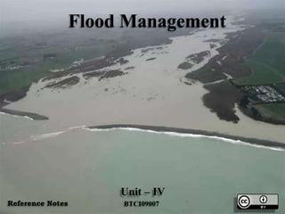
  • 1. Flood Management Unit – IV BTCI09007Reference Notes
  • 2. • Indian rivers and floods, Causes of flooding, Alleviation, Leeves and floodwalls, Floodways, Channel improvement, Flood damage analysis. Flood Management
  • 3. Introduction • “Any flow which is relatively high and which overtops the natural or artificial banks in any reach of a river may be called a flood”. • In rainy season, when heavy rainfall occurs in the catchment area, the flow of the river is increased and sometimes it exceeds the normal carrying capacity of the river. Then the surplus water overtops the banks of the river and submerges the surrounding areas consisting of villages, agricultural lands, etc. This phenomenon is known as flood.
  • 4. Introduction • The floods occurs because of heavy rains, or melting of snow or both when the flow in the river is so high that its natural cross-section is unable to contain it. Apart from the overflow of rivers, the floods may be caused by the failure of some dam, with a sudden release of huge amounts of water, causing considerable damage to life and property.
  • 6. Introduction • When the banks are overtopped, water spreads over the flood plain and thus cause damage to crops and property within the flood plain of the river. Since the flood plain is a desirable location for man and his activities, it is important that floods be controlled so that the damage does not exceed an acceptable limit. The damage caused by floods in terms of loss of life, property and economic loss due to disruption of economic activities are all too well-known. It is not to prevent floods but it is possible to prevent or reduce the damage due to floods by controlling the floods. Thus flood control or flood management is defined as the prevention or reduction of the flood damage.
  • 8. Indian Rivers and Floods • Almost all the rivers of India carry heavy floods during the monsoons when their catchment receives intense and heavy rainfall. In the upper reachs, where the river flows through mountainous terrain or undulating area, there is generally no overflow of the banks during high flows. In low reaches especially where the area is flat, the rivers overflow their banks and cause inundation of low low-lying lands, submerge standing crops and property and disrupt communications. In order to understand the availability of surface water in a country, and its related flood problems, it is always necessary to understand the river stream of that country.
  • 9. Indian Rivers and Floods • In India, from the point of view of flood problem, the rivers can be grouped under the four categories: • (1) Brahmaputra Region • (2) Ganga Region • (3) North-West Region • (4) Central India Deccan Region
  • 10. Brahmaputra Region • This region covers the state of Assam, Northern portions of West Bengal, Manipur, Tripura, Nagaland, Arunachal Pradesh and Mizoram. The main rivers in the region are Brahmaputra, barak and their tributaries like Tista, Tarsa, Jaldhaka and Mahananda. The region receives very heavy rainfall from 110 cm to 640 cm per year, which occurs mostly during the monsoon months of June to September every year. Severe and frequent floods, therefore, do occasionally occur in this region. • The main problems in the Brahmaputra region are overspills, drainage congestion, bank erosion, landslides, aggradation and changes in the river course.
  • 13. Ganga Region • This region covers the states of Uttarakhand, U.P. , Bihar, Himachal Pradesh, Rajasthan, Madhya Pradesh, Haryana, west Bengal, and Delhi. The main rivers in the region are the Ganga and its numerous tributaries like Yamuna, Sone, Gomti, Gandak, Kosi and Mahananda. The annual rainfall in the plains varies from 60 cm in the western part to about 175 cm in the eastern. The variation of rainfall in the slopes of the Himalayas is about 125 to 190 cm. More than 80 % rainfall falls during the normal monsoon season, between June to October. The rainfall and Consequently the flood problem increases from west to east and from south to north. The main flood problems in the region are mostly confined to the northern tributaries which bring in a lot of sediment, overspill their banks and change their courses.
  • 15. North-West Region • This Region covers the state of Jammu and kashmir, Punjab, Parts of Himachal Pradesh, Haryana and Rajasthan. The main rivers in the region are the Indus and its tributaries like Sutlej, Beas, Ravi, Chenab and Jhelum. The annual rainfall in hilly areas of Himachal Pradesh is about 175 cm and about 75 cm in Jammu and Kashmir. In the rest of the area, it decreases from about 60 cm in the east to less than 15 cm in extreme western part of Rajasthan.
  • 16. North-West Region • Compared to Ganga and Brahmaputra river regions, the flood problems in this region are generally mild. However, large scale drainage congestion is felt in this region, particularly in the states of Haryana and Punjab. In the Punjab, However, choes (i.e. Hill torrents) are a problem; cascading down steep slopes, they cause flash floods and extensive sand casting over agricultural lands.
  • 19. Central India Deccan Region • This region covers States like: Andra Pradesh, Karnataka, Tamilnadu, Kerala, Orissa, Maharashtra, Gujarat and parts of Madhya Pradesh. The main rivers in the region are: The Narmada, the Tapi, the Mahanadi, the Godavari, the Krishna and the Cauvery. The area receives its rainfall mainly during the south-west monsoon. The area receives its rainfall mainly during the south-west monsoon. Coastal areas of Andra Pradesh and Tamilnadu receive north-east monsoon also. The annual rainfall over the Western Ghats can be as high as 500 cm, in the remaining areas it varies from about 75 cm to 125 cm. The above rivers are generally stable, having sufficient capacities to carry flood waters, except in the delta areas.
  • 20. Central India Deccan Region • The region, as a whole, does not have a serious flood problem, except that on some rivers of Orissa State. The river Narmada and Tapi occasionally face high floods, adversely affecting areas in the lower reaches in Gujarat State. The small rivers streams of Kerala state, when happen to be in high floods, also cause occasional flood problems. In the delta areas of this region, there is the usual problem of sediment deposition, raising of flood levels, drainage congestion and synchronization of river floods with sea tides. • The most flood-prone area in the Brahamaputra basin and the Northern sub-basins in the Ganga Basin. Thus, the problem of floods varies from basin to basin.
  • 22. South and Central Indian Rivers.
  • 23. Causes of Flooding (Causes of Floods) • Intensity of Rainfall in Catchment area: • Whenever there is heavy precipitation over the catchment in terms of intensity, duration and spread, the river will carry high flow and thus this is the main reason of a rivers to be in flood. • The intensity of rainfall in the catchment area is the main cause of flood. If the rainfall is normal and the storm duration is short, the surface run-off will flow smoothly through the tributaries and rivers will not create any problem to the downstream area. But if the rainfall is very heavy and the storm duration is longer, then the surface run-off will be increased and it may exceed the normal carrying capacity of the river and hence overtopping of the river banks may occur and the surrounding area may get flooded.
  • 25. Causes of Flooding (Causes of Floods) • Topography of the Catchment: • It is obvious that larger the size of the catchment more will be the flood. • The catchment area with steep slope increases the run-off and increase the sediment inflow due to the high velocity of flow. While the catchment area with flatter slope reduces the run-off and reduces the sediment inflow due to the velocity of flow. • The Shape of the basin also definitely affects floods. For a fan- shapped catchment, the time of concentration will be less and hence the storm hydrograph base period will be less and the peak flow will be more. As against this, in the case of an elongated-shaped catchment of equal area and the same storm, the time of concentration will be more. Thus, the storm hydrograph base period will be more and the peak flow will be comparatively less. • Thus, the size, slope and shape of the catchment area directly affects the flow of the river.
  • 26. Causes of Flooding (Causes of Floods) • Sedimentation of Rivers and Reservoirs: Reduction in flood control capacity of reservoir due to unabated heavy silting up will affect the flow of the river. • If the tributaries of a river carry heavy sediment load the river bed goes on silting up gradually every year. It will affect the carrying capacity of the river. Ultimately the cross-section of the river will be shallow and it will not be able to carry the high flood flow. Thus, the sedimentation of rivers and reservoirs are also responsible for the flood.
  • 27. Topography of the Catchment:
  • 28. Causes of Flooding (Causes of Floods) Obstruction in the River flow: • Whenever there is a heavy landslide in the river, it may cause flood on the u/s side due to arrest of flow and consequent rise in water level. Due to heavy rainfall, when the water pressure reaches a maximum value, then suddenly then obstruction may be removed and a high column of water may rush downstream area. • Obstruction in or aggradation of river bed, changes in river course and convulsions resulting in flooding by the river flowing over land outside its channel.
  • 29. Obstruction in the River flow
  • 30. Causes of Flooding (Causes of Floods) • Contraction of River Section: • Inadequate waterways at rail and road crossings will affect river flow. While constructing road or railway bridges across a river, the approach works are done on both banks which reduce cross-section of river. Again, the waterways provided by constructing piers may not be sufficient for let outlet of the high flood flow. In this case, the water rises on the u/s side due to insufficient passage and thus the upstream area may get flooded.
  • 31. Causes of Flooding (Causes of Floods) • Inadequate Cross Drainage Works: • Construction of cross drainage works reduce the depth of flow for the high flood flow. • In cross drainage works like aqueduct the river passes below the canal. Here, the structure which is constructed for the smooth running of the river flow may be inadequate for the high flood flow and water level may rise on the u/s side may submerge the surrounding area.
  • 33. Causes of Flooding (Causes of Floods) • Other Causes: • Floods may be caused due to heavy melting of snow and ice. • In Case there is breach of a dam, the reservoir water may rush towards the downstream side causing heavy flood for a short period. • Sometimes, because of earthquake, it may so happen that the river bed is raised. This may cause flood on the upstream due to the arrest of flow as well as on the downstream, for some distance for a short period.
  • 34. Flood due to breach of a dam
  • 35. Alleviation (Flood Control or Flood Mitigation) • The various methods of flood control (or flood mitigation) and reduction of flood damage can be classified under different categories depending on the attempts made to solve this problem. • The flood control measures can be classified broadly as structural and non-structural measures.
  • 36. Alleviation (Flood Control or Flood Mitigation) • Flood control aims at attempts to • (i) modify the flood, • (ii) modify the susceptibility to flood damage • (iii) modify the loss of burden and bearing the loss or living with floods. • The various flood control measures aim at avoiding damages from floods • (i) by the construction of protective works, • (ii) through the reduction of flood flows by storage, change in land use or similar methods, • (iii) by modifying the susceptibility to flood damage and • (iv) by soil concentration in catchment area,
  • 37. Alleviation (Flood Control or Flood Mitigation)
  • 38. Structural Mitigation Measures • They are of following types: • (i) Storage Reservoirs: • It is the most effective measure of flood disaster mitigation measures. The modern reservoir are mostly multipurpose. The aim of reservoir is to store excess water during flood period and release it when flood subsides. • Generally, the reservoirs are formed on the upstream of the area to be protected or on the head reach of the river.
  • 40. Structural Mitigation Measures • The flood control reservoir may be of two types: • (a) Detention Reservoirs • (b) Retarding Reservoirs
  • 41. Classification of Reservoir • Detention Reservoir In this type of reservoir, the spill ways with adjustable gates provided with the dam so that the flood water may be detained for sometime and then released according to the situation of the downstream area by operating the gates of the spillways. • Retarding Reservoir In this type of reservoir spillways are provided with the dam at such a level an capacity so that the flood discharge is retarded and it takes long time for the flood water to flow completely towards the downstream area. The discharge stops when the water level falls below the crest of the spillways.
  • 44. Structural Mitigation Measures • Confining river flow by embankments (Levees): • Earthen embankments have been the principle methods of controlling flood as a short-term measure. • The leaves are earthen embankments constructed parallel to the river bank to continue the river water within a specified section. Thus the surrounding area may be protected from being flooded with surplus water which flow through the river during the heavy rainfall in catchment area.
  • 45. Confining river flow by Embankments (Levees)
  • 46. Structural Mitigation Measures • Channel Improvement Works: • Work performed to increase the discharge or velocity of stream or to decrease the stage and duration of flood is known as channel improvement works. • It Includes, • (a) Increase in size of cross section by widening and excavation of stream bed. • (b) Increasing velocity of flow in the channel by smoothing the river bed and sides, and removing roughness offered by sand bed, weed growth, etc.
  • 48. Structural Mitigation Measures • (iv) Diversion Works: • From the upstream side of the flood affected area a diversion channel is excavated to connect the river at the d/s area. A diversion channel with a regulator upstream of the important area is constructed. The important area is placed on convex side of the river where inundation and erosion are possible. The diversion channel decreases the stage of flood near the important area, and therefore possible flood disaster may be reduced.
  • 50. Structural Mitigation Measures Flood Wall: • When no space is available for the construction of levee or when it is not suitable to construct the levee due to local site condition, then flood wall is constructed as local flood hazard prevention for some important area situated at low level. • There are masonry or concrete walls constructed just on the river bank. These are trapezoidal in section and act as retaining wall.
  • 52. Structural Mitigation Measures • Flood Ways: • The low lying areas along the course of the river are known as floodways. Floodways are the vast depressions into which a portion of the flood water diverted from a river through a natural or artificial channel is temporarily stored during the rising flood. When the river flow recedes the water from the flood ways returns back to river. The floodway is ordinarily used only during major floods. Floodway may be used for agriculture at other times.
  • 54. Structural Mitigation Measures • Construction of Cut-off • In case of sharp bends in the course of a river, the velocity of flow and the rate of discharge is reduced. During heavy rainfall when large flood discharge approaches the sharp bend of the river, it overflows its banks and submerges the surrounding area. So cut-off may be constructed in the meandering type of river to reduce travel time and the water can flow with high velocity along a straight path.
  • 56. Structural Mitigation Measures • Runoff reduction by watershed management: • It is an indirect method applied to the watershed, which has long- term effect on flood disaster mitigation. Different watersheds management are • (i) Afforestation • (ii) Contour farming • (iii) Contour bunds • (iv) Check bunds • (v) Gullying • (vi) Bank Protection • (vii) Diversion drains • (viii) Strip cropping etc.
  • 57. Runoff reduction by watershed management:
  • 58. Non-Structural Mitigation Measures • The non-structural measures include, modifying the susceptibility to flood damage by • (i) flood plain management • (ii)Flood proofing including disaster preparedness • (iii) response planning • (iv) flood forecasting and warning. • Modifying loss burden by • (i) Disaster relief, • (ii) flood fighting including public awareness, and • (iii) flood insurance.
  • 59. Non-Structural Mitigation Measures • Flood plain Zoning: • Area near the river are the most vulnerable for the flood hazards provided the areas are not a highland. Therefore, people should not be allowed to those flood prone areas for dwelling houses. Places below high flood level should not be recommended for inhabitation. These areas may be used as parks, recreation ground, etc. so that inundation of such areas may result in saving life and properties
  • 61. Non-Structural Mitigation Measures • Flood Forecasting: • The emergency evacuation of the threatened area is one of the most effective means of reducing damage due to flood under certain circumstances. Once the flood occurs, the normal activities of the society are badly disrupted with immense losses. Therefore, flood forecasting is a real necessity to minimized to a great extent. Temporary evacuation of persons and shifting the important property to safer paces could be done before the flood arrives.
  • 63. Non-Structural Mitigation Measures • Flood Proofing: • In cases where certain isolated of high value are threatened by flooding, they may sometimes be individually flood proofed. It essentially consists of a combination of structural change and emergency action. Structural change includes construction of the building wall with some water proofing material, closure of lower level windows and providing some means of watertight closure for the doors. Thus, even through the building may be surrounded by water, the property within it is protected from damage and many normal functions can be carried on. In Case of an industrial plant comprising building, storage yards, roads, etc. may be protected by a ring levee or flood wall.
  • 65. Non-Structural Mitigation Measures • Mathematical Modeling: • In the flood disaster mitigation measures, mathematical model by computer can predict flood intensity and area of inundation whether it is flood in river or a flash flood- due to dam break or dike failure. • When natural flood upstream of a river is known, mathematical model of flood routing can predict the flood intensity at some downstream point of the river. Thus, mathematical modeling techniques can alleviate the flood disaster in the river valley in case of both natural and dam- break flood situation. Mathematical model has become a very powerful tool in this age by the use of modern high- speed computer in different fields of science and technology.
  • 67. Levees and Flood walls • Levees and flood walls are one of the oldest and most widely used methods of protecting land from floodwater. These are essentially longitudinal dams constructed along the river banks roughly parallel to the direction of flow of the river. These serve as artificial high bank of the river and thus prevent the flood water from spilling over to the adjoining land. The flood water is confined between the levees or flood walls and is made to flow down the river without causing any damage to the country side of the levees or flood walls and is made to flow down the river without causing any damage to the country side of the levees or flood walls.
  • 69. Levees • A Levee is an earth dyke or embankment. Levees are most frequently used for flood control because they can be built at relatively low or cost of material available at the site. • It is a sort of an earthen dam constructed along the river. Levees are usually built of material excavated from borrow pits parallel to the levee line. The material should be placed in layers and compacted, with the least previous material being placed along the river side of the levee.
  • 70. Levees • Levee cross section must be adjusted to fit the site and the available materials. The top width of levee is usually governed by the requirements of the movement of maintenance equipment. An adequate space is left between the inner toe of the levee and the top of the borrow ditch to avoid collapse of the ditch bank.
  • 72. Location of Levees • Levees should be located on both the banks such that sufficient area of flow is provided between them to transmit the design flow with a reasonable free board against wave action. • It is often cheaper to place the levees along the high ground. Further in any case, full advantage should be taken of ridges, which permit lower levees and often provide better foundation condition conditions. When a city or agricultural district is to be protected a ring levee which completely encircle the area may be provided.
  • 74. Flood Walls • A levee is an earth dyke or embankment, while a flood wall is usually of masonry or concrete. Flood walls are used in developed area where it is difficult to obtain to obtain enough land for the construction of levees. Because of flat slopes, levees require very large width. If the land is costly or limited, it is more economical to construct flood walls. These are masonry or concrete walls constructed just on the river bank. A flood wall is a sort of gravity dam constructed along the river, proper foundation should be provided and all precautions should be taken against scouring. If there is a back fill on the land side of the wall, it acts as an earth retaining wall.
  • 76. Floodways • The low lying area along the course of the river are known as floodways. Floodways are the large depressions into which a portion of the flood water diverted from a river, the water diverted from a river through a natural or artificial channel is temporarily stored during the rising flood. After the flood receeds in the river, the water stored in these depressions is permitted to flow back to the river. • The flood way serves two function • (i) They create large, shallow reservoirs which store a portion of the flood water and hence decrease the flow in the main channel below the diversion. • (ii) They provide an additional outlet from water and hence increase velocity and decrease stage for some distance above the point of diversion.
  • 77. Floodways • The contraction of floodways is limited by the topography of the valley and the availability of low-value land which can be used for the floodway. As the floodways are normally used only during the period of major floods, the land can be used for agriculture in the rest of the period. The diversion channel carrying the water from the river to the floodways may be naturally or artificial. Water may be admitted to floodways in a number of ways. The water may be diverted over a low spot in the natural bank of the river or through a gap left in the levee line. In some cases a fuse plug levee is provided.
  • 79. Channel Improvement • Channel improvement as a flood control measure can be used to reduce the river stage at a specific point in the reach. A river can be made to carry higher discharges at lower levels by merely improving its hydraulic conditions.
  • 81. Channel Improvement • Various methods of channel improvement can be summarized as follows: • Increase in Size of cross-section of the channel • Realignment of the channel along a shorter route. • Increasing velocity of flow in the channel. • Increasing waterways at crossing.
  • 82. Channel Improvement • Increasing in size of cross-section of the channel: • The increase in size of cross section-to cater for a high designed flood without spilling over the bank is economically practicable only for small streams. In cases of larger rivers, such a method is very expensive. Moreover, there is problem to dispose of excessive excavated material.
  • 83. Increasing in size of cross-section of the channel
  • 84. Channel Improvement • Realignment of the channel along a shorter route: • Realignment of the channel along a shorter route is practicable only in the case of smaller streams and the discharge capacity of streams can be increased. However, this method is economically practicable for small streams with manageable low discharge.
  • 85. Realignment of the channel along a shorter route
  • 86. Increasing velocity of flow in the Channel • The velocity of flow in the channel can be increased by deepening the river, reducing width or by shortening the channel lengths at bends by artificial cutoffs, removing barriers in the channels section and lining the channel to improve its coefficient of rugosity. All these methods are adopted for increasing the velocity of flow if they are economical and practicable
  • 88. Increasing Waterways at Crossing • Generally, there are a number of crossing on the river, such as bridges, culverts, and aqueducts. The inadequacy in the waterways of bridges, culverts, canal cross-drainage works etc. may result in aggravating the flood situation. To avoid this problem, adequate waterways should be provided at crossing after proper evaluation of the ultimate drainage requirement of the basin a the time of any proposed crossing across the drainage line.
  • 90. Channel Improvement • The overall effect of the various methods of the channel improvement is to reduce the stage of river at the time of flood. After adopting the measure of channel improvement, the banks of the channel are not overtopped or less frequently overtopped during the high flood discharge.
  • 91. Flood Damage Analysis • There are two types of flood damages: • Direct Damage: • Indirect Damage: • (i) Direct Damage: Direct Damage results due to physical contact of flood water, for example, damage to crop, damage to houses, damage to human lives and live-stock, damage to public utilities, roadways, rail road, etc. • (ii) Indirect Damage: Indirect Damage result to property or services which are not touched by flood water, but is a loss or damage as a result of interrupted trade or division of rail or roadway traffic or other effect. For example, factories, shops, and business centre in flood affected area may be closed, resulting in loss of their owners, stoppage of industrial production and temporarily unemployment of workers.
  • 93. There are two types of losses due to Flood Disaster. • Tangible Losses • Intangible Losses • Tangible Losses: • The tangible losses are those which can be estimated in terms of some money value.
  • 94. There are two types of losses due to Flood Disaster. • The following are tangible losses: • (i) Damage of Personal properties like buildings, furnitures, electronic goods etc. • (ii) Loss of Crops • (iii) Loss due to disruption of trade, business etc. • (iv) Loss due to disruption of road and railway communications • (v) Cost of relief measures.
  • 95. Tangible Losses • Damage to properties such as buildings, public utilities, roadways, bridges, canals, embankments and telephone lines and electric lines bear significant part of flood damages. These damage are assessed on the basis of estimated cost of repairs.
  • 96. Tangible Losses • Damage to the crops constitute more than 60 % of the total damages in India and hence greater care is needed for its assessment. Thus the correct method of estimating the flood damage of crop is the preliminary estimate prepared just after the flood less the return obtained from replacing after the flood. • Rail road communication in affected areas may be interrupted resulting in reduced earning of railways and transport operations. • Daily wage earnings and smaller peddler working in the affected areas may suffer loss in their daily wages or earnings. • Cost of relief measures should be estimated.
  • 98. Intangible Losses • The Intangiable losses are those which cannot be estimated in money values. The following are the intangiable losses. • (i) Loss of Human life and Cattle • (ii) Loss of health due to disease caused by flood • (iii) Loss Caused by social distress • (iv) Loss due to hindrance in development works of towns or cities • (v) Snake bites and other physical ailments and hardships.
  • 99. Intangible Losses • Loss of human lives in flood may be due to capsize boats, house collapse, etc. Loss of human lives is assessed only in number not in monetary values. But in case of loss of cattle, monetary value can be estimated. • Importance of the analysis of the flood damages is aimed to find realistic assessment of benefit-cost ratio of the flood control schemes.
  • 101. Questions • Explain Various Causes of Floods. • Discuss the use of levees and flood walls for the flood control. What are their relative advantages and Disadvantages. • Explain Structural and non-structural approaches of controlling damages due to floods. • Write a detail note on flood management.
  • 102. References • Irrigation Engineering & Hydraulic Structures: By: Prof S.K.Garg Khanna Publishers • Internet Websites