2011 04-26 powell-street_urban_design_plan
•
1 like•1,479 views

Emeryville Powell Street Urban Design Plan

Recommended
Recommended
More Related Content
What's hot
What's hot (20)
Similar to 2011 04-26 powell-street_urban_design_plan
Similar to 2011 04-26 powell-street_urban_design_plan (20)
More from E'ville Eye
More from E'ville Eye (20)
Recently uploaded
Recently uploaded (20)
2011 04-26 powell-street_urban_design_plan
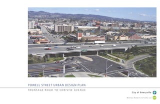
- 1. POWELL STREET URBAN DESIGN PLAN F R O N TA G E R O A D T O C H R I S T I E AV E N U E City of Emeryville Wallace Roberts & Todd, LLC.
- 3. 3P O W E L L S T R E E T U R B A N D E S I G N P L A N : F R O N TA G E R O A D T O C H R I S T I E AV E N U E City of Emeryville Wallace Roberts & Todd, LLC. Acknowledgements City of Emeryville 1333 Park Avenue Emeryville, CA 94608-3517 Office of the City Manager/Emeryville Redevelopment Agency Patrick D. O’Keeffe, City Manager/Agency Executive Director Planning and Building Department Charles S. Bryant (AICP), Director Public Works Department Maurice Kaufman, Public Works Director Department of Economic Development and Housing Helen Bean, Director Michelle De Guzman, Community Economic Development Coordinator Wallace Roberts & Todd, LLC – San Francisco James K. Stickley, ASLA, Principal John R. Gibbs, ASLA, Project Manager / Landscape Architect Julie Peng, Landscape Architect Dan Affleck, Landscape Designer Adopted April 5th, 2011, by vote of the Emeryville City Council
- 4. 4P O W E L L S T R E E T U R B A N D E S I G N P L A N : F R O N TA G E R O A D T O C H R I S T I E AV E N U E City of Emeryville Wallace Roberts & Todd, LLC. Table of Contents Project Approach.........................................................................................................5 Existing Conditions.....................................................................................................6 Site Photos.........................................................................................................6 Aerial Photo and Survey...................................................................................8 ProjectOverview..........................................................................................................7 Phase 1: Multi-Modal Improvements.......................................................................12 Phase 2: Civic Identity................................................................................................16 Phase3: TransitIdentity...............................................................................................23 Supplemental Information........................................................................................26 StreetSections.................................................................................................26 Project Concept Precedents...........................................................................28 Art Elements...................................................................................................29 Bicycle and Pedestrian Safety.........................................................................30 Gateway Parcel Massing Study......................................................................31 AC Transit Route Map....................................................................................32 Transit Network Summary..............................................................................33 General Plan Diagrams...................................................................................34 Powell Street as it currently exists- a vast auto-oriented corridor leading into the city.
- 5. 5P O W E L L S T R E E T U R B A N D E S I G N P L A N : F R O N TA G E R O A D T O C H R I S T I E AV E N U E City of Emeryville Wallace Roberts & Todd, LLC. Market Place Expansion Transit Center BRE Development Area South Bayfront Site B Market Place Expansion Powell Street Urban Design Project Study Area Shellmound Design Guidelines Study Powell Street Urban Design Project Study Area BAY TRAIL BAYTRAIL East Shore State Park PROJECT APPROACH Conceptual Design Narrative Project Guiding Principles The General Plan offers street designations and level of service criteria that• balance -if not favor- pedestrian, bicycle, and transit mobility. The Plan further articulates a vision for connectivity, revitalization, and sustainability. The corridor has been extensively studied. Project designers should incorporate• the recommendations of previous authors including the UC Berkeley Traffic Safety Study. The design should embody the objectives of a “complete street.” The corridor serves as a significant point of welcome to the City for residents,• freeway passerbyes, and regional shoppers. As a gateway, it should effectively announce and characterize Emeryville’s quality of life. In order to provide optimal pedestrian/bicycle/transit circulation and civic• beautification without reducing vehicle travel lanes, the corridor can be widened into the adjacent parcels when redesign of those uses is appropriate. The number of travel lanes on Powell will not change. Regional and City residents should gain improved pedestrian and bicycle access• to waterfront open space resources via the Bay Trail and other conenctions. The project should promote the revitalization of private properties and stimulate• reinvestment/redevelopment. The Powell / Shellmound District is an emerging, mixed-use urban• neighborhood. A finer grain mix of green space, neighborhood serving retail, and pedestrian access is increasingly appropriate. Overall Design Objectives Identify clear project phases that address near term multi-modal improvements (0-5 years) and a long term vision (8-• 15 years). Each phase should maximize improvement to pedestrian, bicycle, and transit functions. Create a distinctive sense of place that makes legible the design principles and builds a positive civic gateway.• Connect the City’s inland neighborhoods to the Bay and extensive waterfront open space via substantial sidewalk/• multi-use path connectors. Prescribe a street geometry where curbs, gutters, and crosswalks each contribute to a clear and regularized• aesthetic. Compress vehicle-oriented layout such as curb radii, lane width, and speed to acceptable minimums to maintain function while improving pedestrian safety and access. Add crosswalks and configure with center median pedestrian refuges.• Treat stormwater runoff to remove pollutants before discharge to Bay.• Configure new building edges and massing to best address issues of height, transparency, street animation, and• entry. Promote safe sidewalk conditions through the use of paving and signage which clearly delineates access zones for• cyclist and pedestrians. Provide a connection point from Powell Street to East Shore State Park.• Project area and nearby development projects
- 6. 6P O W E L L S T R E E T U R B A N D E S I G N P L A N : F R O N TA G E R O A D T O C H R I S T I E AV E N U E City of Emeryville Wallace Roberts & Todd, LLC. EXISTING CONDITIONS PHOTOS Sequential walk on the SOUTH side of Powell St, from Frontage Rd. walking east towards Shellmound St. Sequential walk on the NORTH side of Powell Street, from Frontage Rd. walking east towards Christie Ave. 1. 6. 2. 7. 3. 8. 4. 9. 5. 10. 1. 6. 2. 7. 3. 8. 4. 9. 5. 10.
- 7. 7P O W E L L S T R E E T U R B A N D E S I G N P L A N : F R O N TA G E R O A D T O C H R I S T I E AV E N U E City of Emeryville Wallace Roberts & Todd, LLC. EXISTING CONDITIONS PHOTOS View of Powell St. and Christie Ave. looking west View of historic map describing irregular and unique pattern of the city grid that formed over time. Ground level view of Powell St. Emeryville Crescent at Powell St. and Frontage Rd.
- 8. 8P O W E L L S T R E E T U R B A N D E S I G N P L A N : F R O N TA G E R O A D T O C H R I S T I E AV E N U E City of Emeryville Wallace Roberts & Todd, LLC. EXISTING CONDITIONS AERIAL AND SURVEY 0 40’ 80’ 160’
- 9. 9P O W E L L S T R E E T U R B A N D E S I G N P L A N : F R O N TA G E R O A D T O C H R I S T I E AV E N U E City of Emeryville Wallace Roberts & Todd, LLC. PROJECT OVERVIEW Phase 1: Multi-Modal Improvements Reconfigure south side Powell Bay Trail/sidewalk and landscape to• improve pedestrian/bicycle access from Shellmound to Frontage Road. Greenway is public in character and beautifies the private retail frontage. Provide new Transbay bus stops for San Francisco/Emeryville• communting, also available for use by Emery-Go-Round. Provide various pedestrian and bicycle improvements including those• identified by UC Berkeley Traffic Safety Study. Phase 2: Civic Identity Create an enhanced pedestrian and bicycle path and landscape cor-• ridor on the north side of Powell connecting Christie to the Frontage Road. Provide a center median of a sufficient size to include large trees,• mounded soil above the water table, and other design features that create a positive civic gateway feature. Provide new crosswalk at Powell and Christie intersection.• Create overlook to Emeryville Crescent and gateway to Eastshore• State Park. Phase 3: Transit Vision Provide dedicated transit access from the freeway off ramp through• the Powell Christie intersection (remove stops at ramp locations). Provide new crosswalk at Powell and freeway ramp intersection.• Configure Powell Frontage intersection to allow bus only left turn• access to bridge. Prevent illegal vehicle access through use of hydraulic bollard, signage, and raised, mountable curb. Create an enhanced pedestrian and bicycle path and landscape• corridor on the south side of Powell to mirror the north side.
- 10. 10P O W E L L S T R E E T U R B A N D E S I G N P L A N : F R O N TA G E R O A D T O C H R I S T I E AV E N U E City of Emeryville Wallace Roberts & Todd, LLC. LANE ADDED BRIDGE WIDENED BAY TRAIL EXISTING CONDITIONS PHASE 1 BAY TRAIL BAY TRAIL BAY TRAIL DENNY’S POWELL ST. PLAZA HOTEL I-80 OVERPASS GAS STATION LA-Z- BOY POWELL ST. CHRISTIEAVE. FRONTAGERD. DENNY’S POWELL ST. PLAZA HOTEL I-80 OVERPASS GAS STATION LA-Z- BOY POWELL ST. CHRISTIEAVE. FRONTAGERD. New Pedestrian Signal EXISTING AND PHASE 1 DIAGRAM I-80 OVERPASS New Crosswalk Tighten RadiusArt Opportunity Zone Art Opportunity Zone New Bus Sop Extend Median into Crosswalk to Provide Pedestrian Refuge Straighten Crosswalk Straighten SidewalkNew Bus Stop
- 11. 11P O W E L L S T R E E T U R B A N D E S I G N P L A N : F R O N TA G E R O A D T O C H R I S T I E AV E N U E City of Emeryville Wallace Roberts & Todd, LLC. PHASE 1 SUMMARY OF CHANGES Phase 1: Multi-Modal Improvements Pedestrian and Bicycle Transit Vehicle Image and Atmosphere Straighten Class I path on south side• at Powell Plaza and I-80 underpass from Frontage Rd. to Shellmound Ave. Improve visibility of Bay Trail on south• side as important connection to the waterfront. Improve visibility and crossing safety• at ramp crossings on south side (I-80 eastbound and westbound). Improve safety at I-80 on ramp near• Denny’s by tightening radius and planting the area. Improve pedestrian crossing of• Frontage Rd. on north side by installing pedestrian signal phase on right turn lanes. Improve Bay Trail connection to• Shellmound Ave. at Hotel parking lot. Extend median into crosswalk to• provide pedestrian refuge. Provide striping, special paving and• signage to clearly seperate bike and pedestrian traffic appropriate to path width. Provide interim stops for AC Transit• Transbay busses. Inbound bus stop is at off ramp location. Bus would pull out of traffic per Caltrans. Outbound is off Frontage Rd. Highlight shelters with• contemporary design, lighting, and proximity to sidewalk connection. Consider sponsorship of interim• shelters by businesses and arts groups. Powell St.-Frontage Rd: Add new approach (one-way• northbound, left and thru) for traffic from eastbound I-80 off ramp left-turns. Add new phase to signal timing• at intersection. Powell-I-80 off ramps: Signal operation/phasing to• remain the same, but adjust timings parameters. Powell-Christie: Change existing westbound• bridge approach by adding left- turn lane. Modify eastbound bridge to• accommodate Bay Street garage entry. Adjust timings parameters of• signal operation/phasing. Create new landscape treatment• for south side Powell St. that compliments both civic and retail improvement goals. Provide lighting and/or art• features to convey Bay Trail connection from Christie Ave. to Frontage Rd. on south side. Indicates Project Recommended by UC Berkeley Pedestrian and Bicycle Safety Evalua- tion for the the City of Emeryville at Four Intersections. These Projects are the Current Subject of The Bike and Pedestrian Safety Improvement Project by the City of Emeryville Department of Public Works.
- 12. 12P O W E L L S T R E E T U R B A N D E S I G N P L A N : F R O N TA G E R O A D T O C H R I S T I E AV E N U E City of Emeryville Wallace Roberts & Todd, LLC. PHASE 1: MULTI-MODAL IMPROVEMENTS Southeast corner of Powell St. and Christie Ave. existing condition Southeast corner of Powell St. and Christie Ave. Phase 1 condition View of lighted path under Interstate 80
- 13. 13P O W E L L S T R E E T U R B A N D E S I G N P L A N : F R O N TA G E R O A D T O C H R I S T I E AV E N U E City of Emeryville Wallace Roberts & Todd, LLC. PHASE 1: MULTI-MODAL IMPROVEMENTS
- 14. 14P O W E L L S T R E E T U R B A N D E S I G N P L A N : F R O N TA G E R O A D T O C H R I S T I E AV E N U E City of Emeryville Wallace Roberts & Todd, LLC. PHASE 1: MULTI-MODAL IMPROVEMENTS View of proposed bus stop at corner of Powell St. and I-80 off ramp
- 15. 15P O W E L L S T R E E T U R B A N D E S I G N P L A N : F R O N TA G E R O A D T O C H R I S T I E AV E N U E City of Emeryville Wallace Roberts & Todd, LLC. PHASE 1: MULTI-MODAL IMPROVEMENTS DENNY’S I-80 OVERPASS POWELL ST. PLAZA POWELL ST. GAS STATION LA-Z- BOY CHRISTIEAVE. FRONTAGERD
- 16. 16P O W E L L S T R E E T U R B A N D E S I G N P L A N : F R O N TA G E R O A D T O C H R I S T I E AV E N U E City of Emeryville Wallace Roberts & Todd, LLC. NEW RAMP CONNECTOR NEW CENTRAL BUS SHELTER BUS ONLY LEFT TURN PHASE 2 PHASE 3 BAY TRAIL BAY TRAIL BAY TRAIL BAY TRAIL POWELL ST. PLAZA HOTELI-80 OVERPASS LA-Z- BOY POWELL ST. CHRISTIEAVE. FRONTAGERD. HOTEL I-80 OVERPASS LA-Z- BOY POWELL ST. CHRISTIEAVE. FRONTAGERD. PHASE 2 AND 3 DIAGRAM Straighten North Sidewalk Straighten South Sidewalk Add Crosswalk Add Crosswalk Re-align Crosswalk I-80 OVERPASS I-80 OVERPASS Art Opportunity Zone
- 17. 17P O W E L L S T R E E T U R B A N D E S I G N P L A N : F R O N TA G E R O A D T O C H R I S T I E AV E N U E City of Emeryville Wallace Roberts & Todd, LLC. Pedestrian and Bicycle Transit Vehicle Image and Atmosphere Create new multi-use path and• Class I bicycle facility on north side of Powell St. Create new center median with• pedestrian refuge to improve crossing of Powell St. at Christie Ave. Add new crosswalk on Powell• St. at I-80 off ramps. Modify curb and radius on• northeast corner to provide new crosswalk at Powell St/ Christie Ave. intersection. Provide striping, special paving• and signage to clearly seperate bicycle and pedestrian traffic appropriate to path width. Provide on-going improvement• to existing operations. Improve eastbound I-80• off ramp and Powell St. intersection. Redirect left turn traffic away under overpass and to Powell St.- Frontage Rd.intersection. Restripe westbound lanes on• Powell St. from Christie Ave. to Frontage Rd. Create major new civic• identity from landscape treatments on north side and center median. Add new decorative light• fixtures to north and south side of Powell St. Create opportunities for• more public art on new paths to celebrate and interpret the unique culture of Emeryville. Create overlook at• Emeryville Crescent to reconnect city to Bay and serve as gateway to Eastshore Park. Pedestrian and Bicycle Transit Vehicle Image and Atmosphere Create new Bay Trail/multi-• use path on newly-landscaped south side of Powell connecting Shellmound St. to Bay. Create new center median with• pedestrian refuge to improve crossing of Powell St. at Christie Ave. Provide striping, special paving• and signage to clearly seperate bicycle and pedestrian traffic appropriate to path width. Provide dedicated transit• only lanes and center median station as civic marker and signature gateway feature. Modify signal timing at• Powell St. and Christie Ave. to prioritize bus movements over private vehicles. Provide bus only lane for• westbound I-80 on ramp from Powell St. Restripe eastbound lanes on• Powell from Frontage Road to Christie Ave. Prevent illegal westbound• I-80 onramp access with flexible posts and a hydraulic bollard. Integrate public art into• new transit shelter design through dynamic graphic media, lighting, color, and or form. Complete civic identity• through landscape treatments on south side to match north. Reinstall decorative lights from Phase 2. PHASE 2 AND 3 SUMMARY OF CHANGES Phase 2: Civic Identity Phase 3: Transit Vision
- 18. 18P O W E L L S T R E E T U R B A N D E S I G N P L A N : F R O N TA G E R O A D T O C H R I S T I E AV E N U E City of Emeryville Wallace Roberts & Todd, LLC. PHASE 2: CIVIC IDENTITY Existing condition Southeast corner of Powell St. and Christie Ave. Phase 2 condition View illustrating the landforms proposed for the Phase 2 median Southeast corner of Powell St. and Christie Ave. Phase 1 condition
- 19. 19P O W E L L S T R E E T U R B A N D E S I G N P L A N : F R O N TA G E R O A D T O C H R I S T I E AV E N U E City of Emeryville Wallace Roberts & Todd, LLC. PHASE 2: CIVIC IDENTITY
- 20. 20P O W E L L S T R E E T U R B A N D E S I G N P L A N : F R O N TA G E R O A D T O C H R I S T I E AV E N U E City of Emeryville Wallace Roberts & Todd, LLC. PHASE 2: CIVIC IDENTITY View of proposed Bay Trail Overlook At Emeryville Crescent (Powell St. and Frontage Rd.) View of existing location
- 21. 21P O W E L L S T R E E T U R B A N D E S I G N P L A N : F R O N TA G E R O A D T O C H R I S T I E AV E N U E City of Emeryville Wallace Roberts & Todd, LLC. PHASE 2: CIVIC IDENTITY I-80 OVERPASS POWELL ST. PLAZA NEW DEVELOPMENT PARCEL POWELL ST. LA-Z- BOY CHRISTIEAVE. FRONTAGERD
- 22. 22P O W E L L S T R E E T U R B A N D E S I G N P L A N : F R O N TA G E R O A D T O C H R I S T I E AV E N U E City of Emeryville Wallace Roberts & Todd, LLC. Existing condition Southeast corner of Powell St. and Christie Ave. Phase 2 condition Southeast corner of Powell St. and Christie Ave. Phase 3 condition Northeast corner of Powell St. and Christie Ave. Phase 3 condition PHASE 2: CIVIC IDENTITY
- 23. 23P O W E L L S T R E E T U R B A N D E S I G N P L A N : F R O N TA G E R O A D T O C H R I S T I E AV E N U E City of Emeryville Wallace Roberts & Todd, LLC. PHASE 3: TRANSIT IDENTITY
- 24. 24P O W E L L S T R E E T U R B A N D E S I G N P L A N : F R O N TA G E R O A D T O C H R I S T I E AV E N U E City of Emeryville Wallace Roberts & Todd, LLC. PHASE 3: TRANSIT IDENTITY View of reconfigured Bay Trail connection to crescent overlook and special bus only ramp access
- 25. 25P O W E L L S T R E E T U R B A N D E S I G N P L A N : F R O N TA G E R O A D T O C H R I S T I E AV E N U E City of Emeryville Wallace Roberts & Todd, LLC. PHASE 3: TRANSIT IDENTITY I-80 OVERPASS NEW DEVELOPMENT PARCEL NEW DEVELOPMENT PARCEL POWELL ST. LA-Z- BOY CHRISTIEAVE. FRONTAGERD.
- 26. 26P O W E L L S T R E E T U R B A N D E S I G N P L A N : F R O N TA G E R O A D T O C H R I S T I E AV E N U E City of Emeryville Wallace Roberts & Todd, LLC. Median SidewalkSidewalk 10.5’ 10’10.5’ 10’ 10’ 12’ 6’10’10.5’10.5’10’.510’7’ 13’ Existing Condition Powell St. Section Phase 1 Powell St. Section Median SidewalkSidewalk 10’ 10’10’ 10’ 10’ 12’ 6’10’10’10’10’10’7’ 13’ POWELL STREET CROSS SECTIONS LOOKING WEST TOWARDS FREEWAY
- 27. 27P O W E L L S T R E E T U R B A N D E S I G N P L A N : F R O N TA G E R O A D T O C H R I S T I E AV E N U E City of Emeryville Wallace Roberts & Todd, LLC. POWELL STREET CROSS SECTIONS P H A S E 2 P O W E L L S T S E C T I O N Phase 3 Powell St. Section Phase 2 Powell St. Section Bus Shelter SidewalkSidewalk 11’56’ 11’ 11’ 11’ 8’11’11’ 11’ 11’ 11’8’ 15’15’ 20’20’ P H A S E 2 P O W E LLL LLLLLLL S T S ES C T I O N 30’ Median SidewalkSidewalk 11’10.5’10’.510.5’10.5’10.5’10’7’ 13’ 11’ 11’ 11’ 8’ 15’ 20’ LOOKING WEST TOWARDS FREEWAY
- 28. 28P O W E L L S T R E E T U R B A N D E S I G N P L A N : F R O N TA G E R O A D T O C H R I S T I E AV E N U E City of Emeryville Wallace Roberts & Todd, LLC. SUPPLEMENTAL INFORMATION PROJECT CONCEPT PRECEDENTS Station canopy- Lyon, France Transit boulevard- San Francisco, CA BRT station- Eugene, OregonGrand civic boulevard, Champs Elysees- Paris, France Civic station design- Liege, Belgium
- 29. 29P O W E L L S T R E E T U R B A N D E S I G N P L A N : F R O N TA G E R O A D T O C H R I S T I E AV E N U E City of Emeryville Wallace Roberts & Todd, LLC. SUPPLEMENTAL INFORMATION ART ELEMENTS The Powell Street corridor provides opportunities for art installations and lighting elements that can function as a gateway to the city and an expression of the unique character of Emeryville. This page shows interesting examples from other cities.
- 30. 30P O W E L L S T R E E T U R B A N D E S I G N P L A N : F R O N TA G E R O A D T O C H R I S T I E AV E N U E City of Emeryville Wallace Roberts & Todd, LLC.SUPPLEMENTAL INFORMATION BICYCLE AND PEDESTRIAN SAFETY Signage and striping can clearly direct the flow of traffic and prevent conflict between cylists and pedestrians, as seen in these examples.
- 31. 31P O W E L L S T R E E T U R B A N D E S I G N P L A N : F R O N TA G E R O A D T O C H R I S T I E AV E N U E City of Emeryville Wallace Roberts & Todd, LLC. Massing and Form Description Building Form/Edges: Flexible frontage massing with potential• entries and varying degrees of transparency. (i.e. de Young Museum) FAR shown above 3.5 - 5.0• Massing and Form Description Building Form/Edges: Consistent frontage massing and• architecture with entry positioned at corner and Christie. Towers are symmetrical to the North and South of Powell St. FAR shown above 3.5-5.0• Massing and Form Description Building Form/Edges: Two separate masses are appropriate on• Powell, shown as a tower and 5-story building, with a plaza between and accessed from Powell Street and the site interior. Each building should engage the street with high transparency. Event venue type uses would contribute to the theme of commerce. Scheme shows a second tower to test mass and FAR• FAR shown above 4.5-6.0• SUPPLEMENTAL INFORMATION GATEWAY PARCEL MASSING STUDY ChristieAve Powell St Powell St Powell St ChristieAve ChristieAve Potential Programming Mixed-use with residential, office/commercial, cultural venue• Ground floor retail facing Christie Ave.• Assumes realigned Christie Way• Potential Programming Mixed-use with residential, office/commercial• Ground floor retail facing Christie Ave• Assumes realigned Christie Way• Potential Programming Mixed-use with residential, office/commercial, cultural/event venue• Exhibition space, conference center may be appropriate• Ground floor retail facing Christie Ave• Assumes realigned Christie Way•
- 32. 32P O W E L L S T R E E T U R B A N D E S I G N P L A N : F R O N TA G E R O A D T O C H R I S T I E AV E N U E City of Emeryville Wallace Roberts & Todd, LLC. SUPPLEMENTAL INFORMATION AC TRANSIT ROUTE MAP SOURCE: www.actransit.org
- 33. 33P O W E L L S T R E E T U R B A N D E S I G N P L A N : F R O N TA G E R O A D T O C H R I S T I E AV E N U E City of Emeryville Wallace Roberts & Todd, LLC. C J Z F 57 EM J C Z F 57 EM Emery-Go-Round (local service) Bus Line Designations Transbay Service Late Night (last trip midnight) Commute Hour Service (no midday or night service) Commute Hour Service (no midday or night service) Transbay Service SUPPLEMENTAL INFORMATION TRANSIT NETWORK SUMMARY
- 34. 34P O W E L L S T R E E T U R B A N D E S I G N P L A N : F R O N TA G E R O A D T O C H R I S T I E AV E N U E City of Emeryville Wallace Roberts & Todd, LLC. High Density Residential Medium-High Density Residential Medium Density Residential Mixed Use with Residential Mixed Use with Non-Residential Office/Technology Industrial Public Marina Park/Open Space Other Park Opportunity Regional Retail Overlay Neighborhood Retail Overlay Neighborhood Center Major Hub Transit Center TransitCent er 1/4 M ile 1/4 Mile FRONTAGEROAD EASTSHOREFREEWAY INTERSTATE80 LACOSTEST 65TH ST CHRISTIEAVE 53RD ST HOLLISST HARUFF ST OVERLANDAVE 54TH ST 55TH ST BEAUDRYST POWELL ST 59TH ST 61ST ST 62ND ST 63RD ST HOLLISST DOYLE ST VALLEJOST 64TH ST VALLEJOST OCEAN AVE 65TH ST 67TH ST 66TH ST SHERWIN AVE HALLECKST HUBBARDST HORTONST HOLDENST EMERY ST WATTSST HARLANST HAVENST 45TH ST PARK AVE 43RD ST 41ST ST 45TH ST 47TH ST ESSEXST SALEMST SALEM ST 46TH ST 45TH ST 44TH ST 43RD ST 42ND ST 41ST ST 40TH ST. YERBA BUENA AVE 39TH ST. 38TH ST APGAR ST 36TH ST 37TH ST PERALTA WATTS 47TH ST 48TH ST ADELINEST SANPABLOAVE HORTONST POWELL ST 40TH ST YERBA BUENA AVE SANPABLOAVE CHRISTIE AVE BEACHST PEABODY LN MANDELAPK W Y SHELLMOUNDST ASHBY AVE W. MACARTHUR BLVD SHELLMOUNDST BAYST INTERSTATE 580 STAN FO RD AVE CHIRONWAY WAY SHELLMOUND 0 600 1200 2400300 FEET FIGURE 2-2 Land Use Diagram 2-11 S a n F r a n c i s c o B a y BERKELEY EMERYVILLE OAKLAND EMERYVILLE OAKLAND EMERYVILLE Boat Launching Ramp Fishing Pier Windsurfing Launch FRONTAGEROAD EASTSHOREFREEWAY INTERSTATE80 LACOSTEST 65TH ST CHRISTIEAVE 53RD ST HOLLISST HARUFF ST OVERLANDAVE 54TH ST 55TH ST BEAUDRYST POWELL ST 59TH ST 61ST ST 62ND ST 63RD ST HOLLISST DOYLE ST VALLEJOST 64TH ST VALLEJOST OCEAN AVE 65TH ST 67TH ST 66TH ST SHERWIN AVE HALLECKST HUBBARDST HORTONST HOLDENST EMERY ST WATTSST HARLANST HAVENST 45TH ST PARK AVE 43RD ST 41ST ST 45TH ST 47TH ST ESSEXST SALEMST SALEM ST 46TH ST 45TH ST 44TH ST 43RD ST 42ND ST 41ST ST 40TH ST. YERBA BUENA AVE 39TH ST. 38TH ST APGAR ST 36TH ST 37TH ST PERALTA WATTS 47TH ST 48TH ST ADELINEST SANPABLOAVE HORTONST POWELL ST 40TH ST YERBA BUENA AVE SANPABLOAVE CHRISTIE AVE BEACHST PEABODY LN MANDELAPK W Y SHELLMOUNDST ASHBY AVE W. MACARTHUR BLVD SHELLMOUNDST BAYST INTERSTATE 580 STAN FO RD AVE CHIRONWAY WAY SHELLMOUND 0 600 1200 2400300 FEET MAXIMUM FLOOR AREA RATIOS EMERYVILLE GENERAL PLAN Notes: Maximum FAR may not be attainable on all sites given development standards in the Zoning Ordinance. Bonus FAR is discretionary and will be awarded only after developers demonstrate that projects meet community goals. * FARs are established by Planned Unit Developments (PUDs) and do not include parking in the calculations. Floor Area Ratio (FAR) Base/with Bonus 3.0/ 4.0 3.0/ 4.0 4.0/ 5.5 4.0/ 5.5 1.5/ 2.0 0.75/ 1.25 0.75/ 1.25 1.5/ 2.0 5.5/ 8.0 4.0/ 5.5 5.5/ 8.0 0.75/ 1.25 3.0/ 4.0 4.0/ 5.5 2.3* 0.75/ 1.25 1.0/ 1.5 1.4* 0.75/ 1.25 1.5/ 2.0 3.0/ 4.0 4.0/ 5.54.0/ 5.5 1.5/ 2.0 1.5/ 2.0 3.0/ 4.0 0.75/ 1.25 1.5/2.0 3.0/ 4.0 1.5/ 2.0 FIGURE 2-3 Maximum Floor Area Ratios 2-14 S a n F r a n c i s c o B a y BERKELEY EMERYVILLE OAKLAND EMERYVILLE OAKLAND EMERYVILLE FRONTAGEROAD EASTSHOREFREEWAY INTERSTATE80 LACOSTEST 65TH ST CHRISTIEAVE 53RD ST HOLLISST HARUFF ST OVERLANDAVE 54TH ST 55TH ST BEAUDRYST POWELL ST 59TH ST 61ST ST 62ND ST 63RD ST HOLLISST DOYLE ST VALLEJOST 64TH ST VALLEJOST OCEAN AVE 65TH ST 67TH ST 66TH ST SHERWIN AVE HALLECKST HUBBARDST HORTONST HOLDENST EMERY ST WATTSST HARLANST HAVENST 45TH ST PARK AVE 43RD ST 41ST ST 45TH ST 47TH ST ESSEXST SALEMST SALEM ST 46TH ST 45TH ST 44TH ST 43RD ST 42ND ST 41ST ST 40TH ST. YERBA BUENA AVE 39TH ST. 38TH ST APGAR ST 36TH ST 37TH ST PERALTA WATTS 47TH ST 48TH ST ADELINEST SANPABLOAVE HORTONST POWELL ST 40TH ST YERBA BUENA AVE SANPABLOAVE CHRISTIE AVE BEACHST PEABODY LN MANDELAPK W Y SHELLMOUNDST ASHBY AVE W. MACARTHUR BLVD SHELLMOUNDST BAYST INTERSTATE 580 STAN FO RD AVE CHIRONWAY WAY SHELLMOUND 0 600 1200 2400300 FEET AREAS OF CHANGE AND STABILITY EMERYVILLE GENERAL PLAN Areas of Potential Change Master Plan Areas Areas of Stability To Bay Bridge 2-5 FIGURE 2-1 Areas of Change and Stability– 2009 S a n F r a n c i s c o B a y Transit Center Transit Center BERKELEY EMERYVILLE OAKLAND EMERYVILLE OAKLAND EMERYVILLE Boat Launching Ramp Fishing Pier Windsurfing Launch 0 600 1200 2400300 FEET Amtrak Station Emery Secondary School Emeryville Marketplace Approved Civic Center Anna Yates Elementary School Center for Community Life (proposed) TransitCen ter FRONTAGEROAD EASTSHOREFREEWAY SHELLMOUND ST INTERSTATE80 LACOSTEST 65TH ST CHRISTIEAVE 53RD ST HOLLIS ST HARUFF ST OVERLANDAVE 54TH ST 55TH ST BEAUDRY ST DOYLE ST POWELL ST 59TH ST 61ST ST 62ND ST 63RD ST HOLLIS ST DOYLE ST VALLEJO ST 64TH ST VALLEJO ST OCEAN AVE 65TH ST 67TH ST 66TH ST SHERWIN ST HALLECK ST HUBBARD ST ST HOLDEN EMERY ST WATTSST HARLANST HAVENST ST 45TH PARK AVE 43RD ST 45TH ST 47TH ST SALEMST. 46TH ST. 45TH ST. 44TH ST. 43RD ST. 42ND ST. 41ST ST. 40TH ST. YERBA BUENA AVE 39TH ST. 38TH ST. APGAR ST. 36TH ST. 37TH ST. PERALTA ST. MAGNOLIA ST. 47TH ST 48TH ST ADELINE ST SANPABLO AVE HORTON ST POWELL ST 40TH ST YERBA BUENA AVE. CHRISTIEA VE CHIRON WAY PEABODY RD MANDELAPKW Y SHELLMOUNDST SANPABLO AVE 64TH ST INTERSTATE 80 ASH BY AVE W.MACARTHUR BLVD Neighborhood Center Activity Nodes Neighborhood Retail Overlay Regional Retail Residential Mixed Use Industrial Major Street Large Park Greenway Existing Bike/Ped. Crossing Potential Bike/Ped. Crossing Freeway Gateway Core CITY STRUCTURE EMERYVILLE GENERAL PLAN FIGURE 5-1 City Structure 5-4 SUPPLEMENTAL INFORMATION GENERAL PLAN DIAGRAMS SOURCE: Emerville General Plan January 2009
- 35. 35P O W E L L S T R E E T U R B A N D E S I G N P L A N : F R O N TA G E R O A D T O C H R I S T I E AV E N U E City of Emeryville Wallace Roberts & Todd, LLC. S a n F r a n c i s c o B a y Pedestrianonly BERKELEY EMERYVILLE OAKLAND EMERYVILLE OAKLAND EMERYVILLE FRONTAGEROAD EASTSHOREFREEWAY INTERSTATE80 LACOSTEST 65TH ST CHRISTIEAVE 53RD ST HOLLISST HARUFF ST OVERLANDAVE 54TH ST 55TH ST BEAUDRYSTPOWELL ST 59TH ST 61ST ST 62ND ST 63RD ST HOLLISST DOYLE ST VALLEJOST 64TH ST VALLEJOST OCEAN AVE 65TH ST 67TH ST 66TH ST SHERWIN AVE HALLECKST HUBBARDST HORTONST HOLDENST EMERY ST WATTSST HARLANST HAVENST 45TH ST PARK AVE 43RD ST 41ST ST 45TH ST 47TH ST ESSEXST SALEMST SALEM ST 46TH ST 45TH ST 44TH ST 43RD ST 42ND ST 41ST ST 40TH ST. YERBA BUENA AVE 39TH ST. 38TH ST APGAR ST 36TH ST 37TH ST PERALTA WATTS 47TH ST 48TH ST ADELINEST SANPABLOAVE HORTONST POWELL ST 40TH ST YERBA BUENA AVE SANPABLOAVE CHRISTIE AVE BEACHST PEABODY LN MANDELAPK W Y SHELLMOUNDST ASHBY AVE W. MACARTHUR BLVD SHELLMOUNDST BAYST INTERSTATE 580 STAN FO RD AVE CHIRONWAY WAY SHELLMOUND 0 600 1200 2400300 FEET BAY TRAIL EMERYVILLE GENERAL PLAN Bay Trail Spur Trail Spur Pedestrian Only Trail Existing Overpass Approved Overpass To Bay Bridge To Mandela Parkway via 32nd St FIGURE 3-3 Bay Trail 3-10 S a n F r a n c i s c o B a y Pedestrian and bike access to Bay Bridge BERKELEY EMERYVILLE OAKLAND EMERYVILLE OAKLAND EMERYVILLE FRONTAGEROAD EASTSHOREFREEWAY INTERSTATE80 LACOSTEST 65TH ST CHRISTIEAVE 53RD ST HOLLISST HARUFF ST OVERLANDAVE 54TH ST 55TH ST BEAUDRYST POWELL ST 59TH ST 61ST ST 62ND ST 63RD ST HOLLISST DOYLE ST VALLEJOST 64TH ST VALLEJOST OCEAN AVE 65TH ST 67TH ST 66TH ST SHERWIN AVE HALLECKST HUBBARDST HORTONST HOLDENST EMERY ST WATTSST HARLANST HAVENST 45TH ST PARK AVE 43RD ST 41ST ST 45TH ST 47TH ST ESSEXST SALEMST SALEM ST 46TH ST 45TH ST 44TH ST 43RD ST 42ND ST 41ST ST 40TH ST. YERBA BUENA AVE 39TH ST. 38TH ST APGAR ST 36TH ST 37TH ST PERALTA WATTS 47TH ST 48TH ST ADELINEST SANPABLOAVE HORTONST POWELL ST 40TH ST YERBA BUENA AVE SANPABLOAVE CHRISTIE AVE BEACHST PEABODY LN MANDELAPK W Y SHELLMOUNDST ASHBY AVE W. MACARTHUR BLVD SHELLMOUNDST BAYST INTERSTATE 580 STAN FO RD AVE CHIRONWAY WAY SHELLMOUND 0 600 1200 2400300 FEET BICYCLE SYSTEM EMERYVILLE GENERAL PLAN FRAMEWORK To MacArthur BART To West Oakland BART Existing or Proposed Class I Existing or Proposed Class II & III Bike Boulevard Existing Overpass Approved Overpass/Underpass Proposed Overpass/Underpass Existing Railroad Grade Crossing Grade-separated crossings across I-80 (for pedestrians and bicycles) and the railroad (for all travel modes) north of Powell St FIGURE 3-4 Bicycle System 3-12 S a n F r a n c i s c o B a y To Bay Bridge Transit Cent er Amtrak Station Transit Cent er Transit Cent er 1/4 M ile 1/4 Mile BERKELEY EMERYVILLE OAKLAND EMERYVILLE OAKLAND EMERYVILLE Boat Launching Ramp Fishing Pier Windsurfing Launch FRONTAGEROAD EASTSHOREFREEWAY INTERSTATE80 LACOSTEST 65TH ST CHRISTIEAVE 53RD ST HOLLISST HARUFF ST OVERLANDAVE 54TH ST 55TH ST BEAUDRYST POWELL ST 59TH ST 61ST ST 62ND ST 63RD ST HOLLISST DOYLE ST VALLEJOST 64TH ST VALLEJOST OCEAN AVE 65TH ST 67TH ST 66TH ST SHERWIN AVE HALLECKST HUBBARDST HORTONST HOLDENST EMERY ST WATTSST HARLANST HAVENST 45TH ST PARK AVE 43RD ST 41ST ST 45TH ST 47TH ST ESSEXST SALEMST SALEM ST 46TH ST 45TH ST 44TH ST 43RD ST 42ND ST 41ST ST 40TH ST. YERBA BUENA AVE 39TH ST. 38TH ST APGAR ST 36TH ST 37TH ST PERALTA WATTS 47TH ST 48TH ST ADELINEST SANPABLOAVE HORTONST POWELL ST 40TH ST YERBA BUENA AVE SANPABLOAVE CHRISTIE AVE BEACHST PEABODY LN MANDELAPK W Y SHELLMOUNDST ASHBY AVE W. MACARTHUR BLVD SHELLMOUNDST BAYST INTERSTATE 580 STAN FO RD AVE CHIRONWAY WAY SHELLMOUND 0 600 1200 2400300 FEET CIRCULATION EMERYVILLE GENERAL PLAN To MacArthur BART To West Oakland BART Transit Street Connector Street Local Street Auto Dominated Highway Regional Rail Bikeways Existing or Proposed Class I Existing or Proposed Class II & III Bike Boulevard Pedestrian-only Trail Pedestrian Priority Zone Existing Overpass Approved Overpass/Underpass (Pedestrian Only) Proposed Overpass/Underpass Existing Railroad Grade Crossing Major Transit Hub Grade-separated crossings across I-80 (for pedestrians and bicycles) and the railroad (for all travel modes) north of Powell St FIGURE 3-1 Circulation 3-6 S a n F r a n c i s c o B a y Transit Center Amtrak Station Transit Cente r 1/4 M ile 1/4 Mile BERKELEY EMERYVILLE OAKLAND EMERYVILLE OAKLAND EMERYVILLE FRONTAGEROAD EASTSHOREFREEWAY INTERSTATE80 LACOSTEST 65TH ST CHRISTIEAVE 53RD ST HOLLISST HARUFF ST OVERLANDAVE 54TH ST 55TH ST BEAUDRYST POWELL ST 59TH ST 61ST ST 62ND ST 63RD ST HOLLISST DOYLE ST VALLEJOST 64TH ST VALLEJOST OCEAN AVE 65TH ST 67TH ST 66TH ST SHERWIN AVE HALLECKST HUBBARDST HORTONST HOLDENST EMERY ST WATTSST HARLANST HAVENST 45TH ST PARK AVE 43RD ST 41ST ST 45TH ST 47TH ST ESSEXST SALEMST SALEM ST 46TH ST 45TH ST 44TH ST 43RD ST 42ND ST 41ST ST 40TH ST. YERBA BUENA AVE 39TH ST. 38TH ST APGAR ST 36TH ST 37TH ST PERALTA WATTS 47TH ST 48TH ST ADELINEST SANPABLOAVE HORTONST POWELL ST 40TH ST YERBA BUENA AVE SANPABLOAVE CHRISTIE AVE BEACHST PEABODY LN MANDELAPK W Y SHELLMOUNDST ASHBY AVE W. MACARTHUR BLVD SHELLMOUNDST BAYST INTERSTATE 580 STAN FO RD AVE CHIRONWAY WAY SHELLMOUND 0 600 1200 2400300 FEET TRANSIT SYSTEM EMERYVILLE GENERAL PLAN To MacArthur BART To West Oakland BART Transit Streets Regional Rail Existing Crossing (at grade) Major Transit Hub Future grade-separated crossing of the railroad between Powell St and Ashby Ave at location to be determined FIGURE 3-5 Transit System 3-13 SUPPLEMENTAL INFORMATION GENERAL PLAN DIAGRAMS SOURCE: Emerville General Plan January 2009
- 36. Wallace Roberts & Todd, LLC.